IMAGES TAKEN NEAR TO
MAYBOLE, KA19 8HN
Introduction
This page details the photographs taken nearby to KA19 8HN by members of the Geograph project.
The Geograph project started in 2005 with the aim of publishing, organising and preserving representative images for every square kilometre of Great Britain, Ireland and the Isle of Man.

There are currently over 7.5m images from over14,400 individuals and you can help contribute to the project by visiting https://www.geograph.org.uk
Image Map
Images are licensed for reuse under creativecommons.org/licenses/by-sa/2.0
Notes
- Clicking on the map will re-center to the selected point.
- The higher the marker number, the further away the image location is from the centre of the postcode.
Image Listing (19 Images Found)
Images are licensed for reuse under creativecommons.org/licenses/by-sa/2.0
Image
Details
Distance
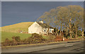
7
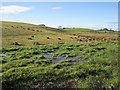
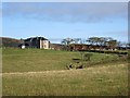
Wet ground, Mosside
The wet grassland has been recently fenced off. A view from a layby on the A77.
Image: © Richard Webb
Taken: 14 Oct 2012
0.08 miles
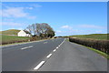
8
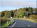
Vultures
The indescribably ugly average speed cameras. Usually they are a temporary feature, but on the A77 you are lumbered with them permanently.
An even uglier speed governing device already exists on Scotland's roads - the caravan, only they don't log your journeys.
Image: © Richard Webb
Taken: 14 Oct 2012
0.10 miles
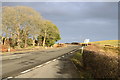
10
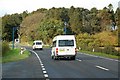
You Are Being Watched
Average speed cameras on the A77 between Maybole and Kirkoswald.
Image: © Mary and Angus Hogg
Taken: 2 Oct 2008
0.11 miles