IMAGES TAKEN NEAR TO
MAYBOLE, KA19 8EQ
Introduction
This page details the photographs taken nearby to KA19 8EQ by members of the Geograph project.
The Geograph project started in 2005 with the aim of publishing, organising and preserving representative images for every square kilometre of Great Britain, Ireland and the Isle of Man.

There are currently over 7.5m images from over14,400 individuals and you can help contribute to the project by visiting https://www.geograph.org.uk
Image Map
Images are licensed for reuse under creativecommons.org/licenses/by-sa/2.0
Notes
- Clicking on the map will re-center to the selected point.
- The higher the marker number, the further away the image location is from the centre of the postcode.
Image Listing (8 Images Found)
Images are licensed for reuse under creativecommons.org/licenses/by-sa/2.0
Image
Details
Distance
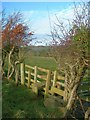
1
Wet, Wet, Wet
Very muddy field edges at Knockdon after a lengthy period of wet winter weather.
Image: © Mary and Angus Hogg
Taken: 9 Dec 2007
0.11 miles
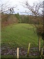
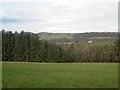
2
Field Corner
The late afternoon November sunshine gives this shot a gentle autumn glow.
Image: © Mary and Angus Hogg
Taken: 11 Nov 2007
0.14 miles
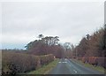
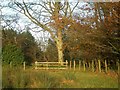
7
Culroy Bridge
The bridge across Culroy Burn, viewed on a chilly December morning.
Image: © Mary and Angus Hogg
Taken: 19 Dec 2007
0.23 miles