IMAGES TAKEN NEAR TO
MAYBOLE, KA19 8EG
Introduction
This page details the photographs taken nearby to KA19 8EG by members of the Geograph project.
The Geograph project started in 2005 with the aim of publishing, organising and preserving representative images for every square kilometre of Great Britain, Ireland and the Isle of Man.

There are currently over 7.5m images from over14,400 individuals and you can help contribute to the project by visiting https://www.geograph.org.uk
Image Map
Images are licensed for reuse under creativecommons.org/licenses/by-sa/2.0
Notes
- Clicking on the map will re-center to the selected point.
- The higher the marker number, the further away the image location is from the centre of the postcode.
Image Listing (6 Images Found)
Images are licensed for reuse under creativecommons.org/licenses/by-sa/2.0
Image
Details
Distance
2
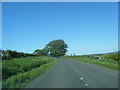
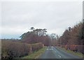
Low Milton Cottage entrance
The entrance to Low Milton Cottage can just be seen by the white gatepost in the near distance.
Image: © Malcolm Neal
Taken: 29 Aug 2019
0.12 miles
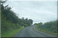
3
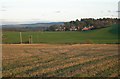
Stubble Field
The condition of the field shows how sticky the soil is here - deposited during the last Ice Age - and how wet the weather has been.
Image: © Mary and Angus Hogg
Taken: 11 Nov 2007
0.19 miles
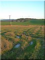
4
St Helen's Well
The lochan contains the old St Helen's Well. In bygone days, its waters were believed to cure ailing children if taken on Mayday. Many Maybole mothers used to walk the 5 mile round trip on Mayday to get a jug of water from St Helen's if they thought that their offsprings weren't thriving as they should. (Source: "Maybole - Carrick's Capital" by James T Gray)
Image: © Mary and Angus Hogg
Taken: 10 Jan 2007
0.20 miles
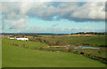
6
Down To The Burn
Viewed in late-afternoon November sunshine. The houses in the background are in the next square.
Image: © Mary and Angus Hogg
Taken: 11 Nov 2007
0.23 miles