IMAGES TAKEN NEAR TO
MAYBOLE, KA19 8ED
Introduction
This page details the photographs taken nearby to KA19 8ED by members of the Geograph project.
The Geograph project started in 2005 with the aim of publishing, organising and preserving representative images for every square kilometre of Great Britain, Ireland and the Isle of Man.

There are currently over 7.5m images from over14,400 individuals and you can help contribute to the project by visiting https://www.geograph.org.uk
Image Map
Images are licensed for reuse under creativecommons.org/licenses/by-sa/2.0
Notes
- Clicking on the map will re-center to the selected point.
- The higher the marker number, the further away the image location is from the centre of the postcode.
Image Listing (6 Images Found)
Images are licensed for reuse under creativecommons.org/licenses/by-sa/2.0
Image
Details
Distance
1
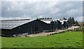
Garryhorn
New cattle housing on a large scale, supplied by the surrounding grassland. The sheds appeared occupied, but some cattle (Holsteins) were out.
Image: © Richard Webb
Taken: 13 Aug 2014
0.03 miles
2
Holstein heifers
Young cattle at a large dairy farm.
Image: © Richard Webb
Taken: 13 Aug 2014
0.17 miles
3
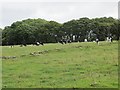
Cattle, Garryhorn
Grazing on the Carrick Hills.
Image: © Richard Webb
Taken: 13 Aug 2014
0.18 miles
4
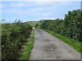
Minor road, Garryhorn
I suspect the Grand Old Duke of York is involved with Sustrans, for some reason the planners of the National Cycle Network have routed two climbs of the Carrick Hills between Ayr and Maybole.
Image: © Richard Webb
Taken: 13 Aug 2014
0.20 miles
5
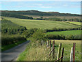
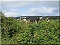
Road to Garryhorn
Looking NNW down the hill towards Garryhorn, showing farmland and woodland
Image: © Mary and Angus Hogg
Taken: 31 Aug 2006
0.23 miles
6
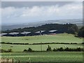
Cattle sheds, Garryhorn
A mostly indoor dairy, although there were cows outside grazing in several places. These new complexes are becoming familiar in southwestern Scotland.
Image: © Richard Webb
Taken: 13 Aug 2014
0.23 miles