IMAGES TAKEN NEAR TO
MAYBOLE, KA19 8DY
Introduction
This page details the photographs taken nearby to KA19 8DY by members of the Geograph project.
The Geograph project started in 2005 with the aim of publishing, organising and preserving representative images for every square kilometre of Great Britain, Ireland and the Isle of Man.

There are currently over 7.5m images from over14,400 individuals and you can help contribute to the project by visiting https://www.geograph.org.uk
Image Map
Images are licensed for reuse under creativecommons.org/licenses/by-sa/2.0
Notes
- Clicking on the map will re-center to the selected point.
- The higher the marker number, the further away the image location is from the centre of the postcode.
Image Listing (3 Images Found)
Images are licensed for reuse under creativecommons.org/licenses/by-sa/2.0
Image
Details
Distance
1
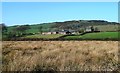
Towards Trees Farm
A February view taken from the next square.
Image: © Mary and Angus Hogg
Taken: 26 Feb 2019
0.05 miles
2
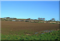
Trees Farm
Rich farmland on the south-facing slopes of the Carrick Hills, near Maybole.
Image: © Mary and Angus Hogg
Taken: 16 Jan 2007
0.07 miles
3
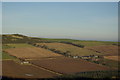
Old Trees & Trees
Viewed from the northeastern slopes of Mochrum Hill
Image: © Leslie Barrie
Taken: 27 Dec 2008
0.15 miles