IMAGES TAKEN NEAR TO
Cassillis, MAYBOLE, KA19 8DN
Introduction
This page details the photographs taken nearby to Cassillis, KA19 8DN by members of the Geograph project.
The Geograph project started in 2005 with the aim of publishing, organising and preserving representative images for every square kilometre of Great Britain, Ireland and the Isle of Man.

There are currently over 7.5m images from over14,400 individuals and you can help contribute to the project by visiting https://www.geograph.org.uk
Image Map
Images are licensed for reuse under creativecommons.org/licenses/by-sa/2.0
Notes
- Clicking on the map will re-center to the selected point.
- The higher the marker number, the further away the image location is from the centre of the postcode.
Image Listing (10 Images Found)
Images are licensed for reuse under creativecommons.org/licenses/by-sa/2.0
Image
Details
Distance
2
Cassillis railway station (site), Ayrshire
Opened in 1856 by the Ayr & Maybole Junction Railway, which later became part of the Glasgow & South Western Railway, this station closed in 1954.
View north west from the road. The station building on the far left, and the rest of the site had become an industrial and business park when this image was taken, but otherwise doesn't seem to have changed much since Image was taken.
Image: © Nigel Thompson
Taken: 9 May 2019
0.04 miles
3
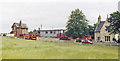
Cassillis station (remains), 1986
View NE, towards Ayr: ex-Glasgow & South Western (Glasgow) - Ayr - Girvan - Stranraer main line. The station had been closed from 6/12/54, but seems now to be well preserved in private hands; the line although not visible here is still active.
Image: © Ben Brooksbank
Taken: 6 Jul 1986
0.04 miles
4
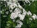
Ne'er Cast A Clout
The old Scottish saying "Ne'er cast a clout till May's oot" refers to the blossom of the Hawthorn, also called May blossom in Scotland. When the Hawthorn is in flower, it's safe to put away your winter clothes. The Hawthorn (Crataegus monogyna) is a member of the Rose family.
Image: © Mary and Angus Hogg
Taken: 28 May 2007
0.15 miles
5
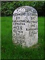
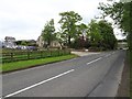
Old Milestone by the A77, Hogg's Corner, north of Maybole
By the A77, in parish of Maybole (Carrick District), junction with the B7045, 3 miles North of Maybole, South angle. Photo from 2024 https://www.facebook.com/groups/148269922014080/permalink/2640484972792550
Inscription reads:- : NSTewaRT / BY / KiRKmichaEL / & STRaiTon / {arrow} 38 / Girvan / BY / Crosshill / & Dailly / {arrow} 16 : : GIRVaN / BY / Maybole / and / KirKoswald / 15 {arrow} :
Surveyed
Milestone Society National ID: AYS_AYMBA06A.
Image: © Milestone Society
Taken: 1 Jan 2009
0.20 miles
6
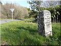
Guide stone at Hoggs Corner, Minishant
This is where two roads to Girvan part.
Image: © Humphrey Bolton
Taken: 1 May 2013
0.20 miles

8
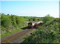
The Girvan Train
The 09.43 train from Ayr, heading for Maybole and Girvan.
Image: © Mary and Angus Hogg
Taken: 4 May 2007
0.21 miles
9
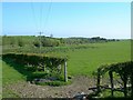
Farmland view
Looking through the open gateway towards the railway line. The lower land is very damp, as indicated by the growth of rushes.
Image: © Mary and Angus Hogg
Taken: 4 May 2007
0.23 miles
10
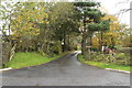
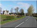
Road into Crorieshill
Grand name for a Farm.
Image: © Billy McCrorie
Taken: 26 Oct 2017
0.23 miles