IMAGES TAKEN NEAR TO
MAYBOLE, KA19 8DF
Introduction
This page details the photographs taken nearby to KA19 8DF by members of the Geograph project.
The Geograph project started in 2005 with the aim of publishing, organising and preserving representative images for every square kilometre of Great Britain, Ireland and the Isle of Man.

There are currently over 7.5m images from over14,400 individuals and you can help contribute to the project by visiting https://www.geograph.org.uk
Image Map
Images are licensed for reuse under creativecommons.org/licenses/by-sa/2.0
Notes
- Clicking on the map will re-center to the selected point.
- The higher the marker number, the further away the image location is from the centre of the postcode.
Image Listing (34 Images Found)
Images are licensed for reuse under creativecommons.org/licenses/by-sa/2.0
Image
Details
Distance
1
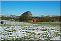
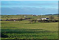
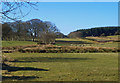
Kirklandhill Farm
Located on Kirklandhill Path on the north side of Maybole. Cargilston Farm is shown in the background.
Image: © Mary and Angus Hogg
Taken: 31 Jan 2019
0.05 miles
2
Cargilston Farm view
Cargilston lies on the far left of this shot. Viewed from the route of the Maybole bypass.
Image: © Mary and Angus Hogg
Taken: 31 Jan 2019
0.05 miles
3
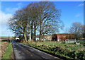
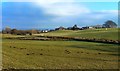
Kirklandhill Farm
Viewed on one of the rare bright days of February 2020.
Image: © Mary and Angus Hogg
Taken: 16 Feb 2020
0.05 miles
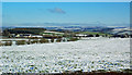
5
Cargilston Farm View
Viewed on a fine early-January afternoon looking towards Cargilston Farm from the old track that leads to Kirklandhill Farm.
Image: © Mary and Angus Hogg
Taken: 9 Jan 2019
0.09 miles
6
Cargilston Farm
Maybole was a stronghold for the Covenanting cause of the late 17th century. One of the leading Covenanters, Donald Cargill, preached at a conventicle at Ladycross in May 1681 Image Local place names record the times – the Preaching Brae Image, Cargilston Farm, Cargill Avenue, Cargill Road and the former Cargill Church.
Image: © Mary and Angus Hogg
Taken: 6 Feb 2015
0.10 miles
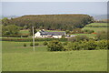
8
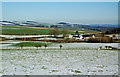
Cargilston Farm
A wintry late-January scene viewed from the next square.
Image: © Mary and Angus Hogg
Taken: 31 Jan 2019
0.11 miles
9
Cargilston Farmland
A late-February view, looking towards the Covenanters' Memorial. For information about the historical significance of this area, see Image
Image: © Mary and Angus Hogg
Taken: 25 Feb 2018
0.14 miles
10
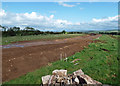
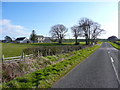
Progress on Maybole's bypass at Kirklandhill Path
Viewed from the demolished remains of Kirklandhill Cottage showing the route of the bypass towards the north-east.
Image: © Mary and Angus Hogg
Taken: 31 Aug 2019
0.14 miles