IMAGES TAKEN NEAR TO
Elms Crescent, MAYBOLE, KA19 8BF
Introduction
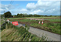
This page details the photographs taken nearby to Elms Crescent, KA19 8BF by members of the Geograph project.
The Geograph project started in 2005 with the aim of publishing, organising and preserving representative images for every square kilometre of Great Britain, Ireland and the Isle of Man.

There are currently over 7.5m images from over14,400 individuals and you can help contribute to the project by visiting https://www.geograph.org.uk
Image Map
Images are licensed for reuse under creativecommons.org/licenses/by-sa/2.0
Notes
- Clicking on the map will re-center to the selected point.
- The higher the marker number, the further away the image location is from the centre of the postcode.
Image Listing (80 Images Found)
Images are licensed for reuse under creativecommons.org/licenses/by-sa/2.0
Image
Details
Distance
1
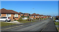
Elms Drive, Maybole
Part of a modern housing development on the north side of Maybole.
Image: © Mary and Angus Hogg
Taken: 25 Feb 2018
0.05 miles
2
Cargill Avenue
One of the routes leading into modern housing areas in Maybole. The road is named after the Covenanting preacher, Donald Cargill, who was very active in this area during the mid-17th century.
Image: © Mary and Angus Hogg
Taken: 25 Feb 2018
0.11 miles
3
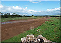
Kirklandhill Path
The planned Maybole bypass will cross Kirklandhill Path close to this spot, after climbing up from the A77, crossing the B7023 and Gardenrose Path, and skirting the northern edge of the town. Advance preparation work has cleared the roadside vegetation.
Image: © Mary and Angus Hogg
Taken: 31 Jan 2019
0.14 miles
4
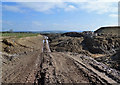
Kirklandhill Path moonscape
A moonscape view on the Maybole bypass route between Kirklandhill Path and Alloway Road. There will be little work at this site while Gardenrose Path is closed. Image shows the site seven months previously.
Image: © Mary and Angus Hogg
Taken: 22 Mar 2020
0.15 miles
5
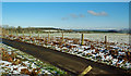
Progress on Maybole's bypass at Kirklandhill Path
Viewed from the demolished remains of Kirklandhill Cottage showing the route of the bypass towards the north-east.
Image: © Mary and Angus Hogg
Taken: 31 Aug 2019
0.15 miles
6
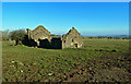
Ruin at Kirklandhill
Located on Kirklandhill Farm, near Maybole. The new bypass will go near this site - see Image
Image: © Mary and Angus Hogg
Taken: 25 Feb 2018
0.15 miles
7
Kirklandhill Path view
The Maybole bypass will cross Kirklandhill Path near this spot.
Image: © Mary and Angus Hogg
Taken: 31 Jan 2019
0.16 miles
8
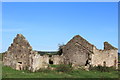
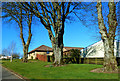
Kirklandhill Cottage
Ruin north of Maybole
Image: © Leslie Barrie
Taken: 29 Sep 2013
0.16 miles
9
Kirklandhill Cottage demolished
The old cottage on Kirklandhill Path has been demolished as part of the Maybole bypass development. For a previous view, see Image taken in January 2019.
Image: © Mary and Angus Hogg
Taken: 31 Aug 2019
0.16 miles
10
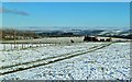
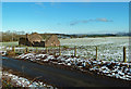
Kirklandhill Cottage in the snow
The Maybole bypass will go close to this site.
Image: © Mary and Angus Hogg
Taken: 31 Jan 2019
0.16 miles