IMAGES TAKEN NEAR TO
Chesney Grove, MAYBOLE, KA19 8AP
Introduction
This page details the photographs taken nearby to Chesney Grove, KA19 8AP by members of the Geograph project.
The Geograph project started in 2005 with the aim of publishing, organising and preserving representative images for every square kilometre of Great Britain, Ireland and the Isle of Man.

There are currently over 7.5m images from over14,400 individuals and you can help contribute to the project by visiting https://www.geograph.org.uk
Image Map
Images are licensed for reuse under creativecommons.org/licenses/by-sa/2.0
Notes
- Clicking on the map will re-center to the selected point.
- The higher the marker number, the further away the image location is from the centre of the postcode.
Image Listing (79 Images Found)
Images are licensed for reuse under creativecommons.org/licenses/by-sa/2.0
Image
Details
Distance
1
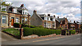
Culzean Road, Maybole
Traditional stone houses in Maybole's Culzean Road.
Image: © Mary and Angus Hogg
Taken: 2 May 2014
0.09 miles
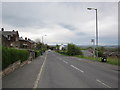
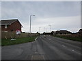
2
Kincraig Avenue
From the Culzean road.
Image: © Billy McCrorie
Taken: 1 May 2012
0.09 miles
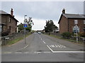
3
Culzean Road
From the junction with McAdam Way looking towards Maybole.
Image: © Billy McCrorie
Taken: 1 May 2012
0.10 miles
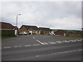
4
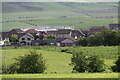
Houses at Maybole
Viewed from the by-pass bridge above Gardenrose Path. Unfinished building is the New Community Campus.
Image: © Billy McCrorie
Taken: 14 May 2022
0.10 miles
5
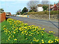
Daffodils at McAdam Way
The daffodils were planted on the grass banking between McAdam Way and Culzean Road.
Image: © Mary and Angus Hogg
Taken: 29 Mar 2022
0.10 miles
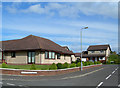
7
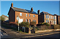
The Covenanters Gathered Here
The right-hand house on the first block, the one with the solar panels, is called Muster Lea. The name comes from a field known as the "Muster Lea" where the Maybole Covenanters gathered before going to the battle of Bothwell Bridge in 1679. What happened there is shown at Image
Image: © Mary and Angus Hogg
Taken: 2 Dec 2014
0.12 miles
8
Burns Drive
Looking over Maybole towards the hills at Straiton from Burns Drive.
Image: © Billy McCrorie
Taken: 1 May 2012
0.12 miles
9
The Site Of The Town Gallows
New housing, located near the hill where the town gallows formerly stood. The last man hanged here was a Girvan man for killing his neighbour in 1718. Eye witnesses to the crime could not be produced, but the fact that he was a Girvan man was sufficient for his Maybole judges to convict him. (Source: "Maybole - Carrick's Capital" by James T Gray)
Image: © Mary and Angus Hogg
Taken: 22 Sep 2006
0.13 miles
10
Maidens Road
From the junction with Burns Drive looking up towards Gallowhill Avenue.
Image: © Billy McCrorie
Taken: 1 May 2012
0.13 miles