IMAGES TAKEN NEAR TO
Cargill Road, MAYBOLE, KA19 8AF
Introduction
This page details the photographs taken nearby to Cargill Road, KA19 8AF by members of the Geograph project.
The Geograph project started in 2005 with the aim of publishing, organising and preserving representative images for every square kilometre of Great Britain, Ireland and the Isle of Man.

There are currently over 7.5m images from over14,400 individuals and you can help contribute to the project by visiting https://www.geograph.org.uk
Image Map
Images are licensed for reuse under creativecommons.org/licenses/by-sa/2.0
Notes
- Clicking on the map will re-center to the selected point.
- The higher the marker number, the further away the image location is from the centre of the postcode.
Image Listing (439 Images Found)
Images are licensed for reuse under creativecommons.org/licenses/by-sa/2.0
Image
Details
Distance
3
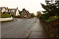
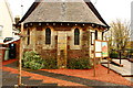
St Oswald Church
Maybole's Episcopal Church, located at the bottom of Gardenrose Path.
Image: © Mary and Angus Hogg
Taken: 16 Sep 2006
0.02 miles
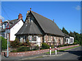
6
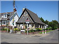
Maybole Church
Church at the junction of Gardenrose Path and Cargill Rd.
Image: © Billy McCrorie
Taken: 13 Jul 2011
0.03 miles
9
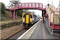
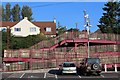
Train arriving from Ayr at Maybole Station
Image: © Billy McCrorie
Taken: 28 Jan 2016
0.03 miles
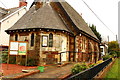
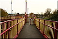
10
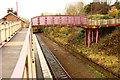
Railway Footbridge, Maybole Station
Image: © Billy McCrorie
Taken: 14 Nov 2016
0.03 miles