IMAGES TAKEN NEAR TO
Alloway Road, MAYBOLE, KA19 8AA
Introduction
This page details the photographs taken nearby to Alloway Road, KA19 8AA by members of the Geograph project.
The Geograph project started in 2005 with the aim of publishing, organising and preserving representative images for every square kilometre of Great Britain, Ireland and the Isle of Man.

There are currently over 7.5m images from over14,400 individuals and you can help contribute to the project by visiting https://www.geograph.org.uk
Image Map
Images are licensed for reuse under creativecommons.org/licenses/by-sa/2.0
Notes
- Clicking on the map will re-center to the selected point.
- The higher the marker number, the further away the image location is from the centre of the postcode.
Image Listing (104 Images Found)
Images are licensed for reuse under creativecommons.org/licenses/by-sa/2.0
Image
Details
Distance
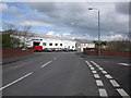
2
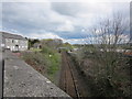
Maybole Railway Line
Looking towards the footbridge and heading for Ayr.
Image: © Billy McCrorie
Taken: 24 Apr 2012
0.09 miles
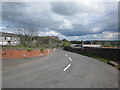
3
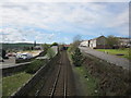
Maybole Railway Line
Going towards Maybole Station. Alloway road on the right the Redbrae Road on the left.
Image: © Billy McCrorie
Taken: 24 Apr 2012
0.09 miles
4
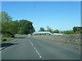
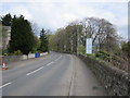
B7024 Alloway Road with railway footbridge in view
Image: © Colin Pyle
Taken: 10 Jun 2015
0.10 miles
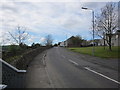
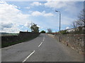
5
Alloway Road
In the direction of Culroy.
Image: © Billy McCrorie
Taken: 24 Apr 2012
0.10 miles
6
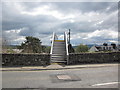
Railway Footbridge
From the Alloway Road.
Image: © Billy McCrorie
Taken: 24 Apr 2012
0.10 miles
7
Railway Footbridge
From the corner of the Redbrae.
Image: © Billy McCrorie
Taken: 24 Apr 2012
0.10 miles
8
The Redbrae
Looking up towards where the Redbrae meets the Alloway Road.
Image: © Billy McCrorie
Taken: 24 Apr 2012
0.10 miles
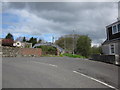
9
Alloway Road
At the junction with Redbrae, road bridge going over the railway.
Image: © Billy McCrorie
Taken: 24 Apr 2012
0.11 miles
10
The Redbrae
Heading down towards the Cassillis Road.
Image: © Billy McCrorie
Taken: 24 Apr 2012
0.11 miles