IMAGES TAKEN NEAR TO
Dailly Road, MAYBOLE, KA19 7RW
Introduction
This page details the photographs taken nearby to Dailly Road, KA19 7RW by members of the Geograph project.
The Geograph project started in 2005 with the aim of publishing, organising and preserving representative images for every square kilometre of Great Britain, Ireland and the Isle of Man.

There are currently over 7.5m images from over14,400 individuals and you can help contribute to the project by visiting https://www.geograph.org.uk
Image Map
Images are licensed for reuse under creativecommons.org/licenses/by-sa/2.0
Notes
- Clicking on the map will re-center to the selected point.
- The higher the marker number, the further away the image location is from the centre of the postcode.
Image Listing (207 Images Found)
Images are licensed for reuse under creativecommons.org/licenses/by-sa/2.0
Image
Details
Distance
1
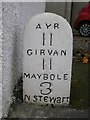
Old Milestone by the B7023, Crosshill, Kirkmichael parish
Stone post by the B7023, Dailly Road in parish of Kirkmichael (Carrick District), Crosshill, Northwest corner of crossroads in village, next to finger post: AY_NS3206 Image
Inscription reads:-
AYR
11
GIRVAN
11
MAYBOLE
3
N.STEWart
(31)
Surveyed
Milestone Society National ID: AYS_MBGVS03
Image: © Milestone Society
Taken: Unknown
0.00 miles
2
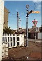
Old Direction sign - Signpost by the B7023, Crosshill
Annulus finial - 2 arms; by the B7023, in parish of Kirkmichael (South Ayrshire District), Dailly Road junction with King Street, Crosshill. Adjacent to Milestone: AYS_MBGVS03 https://www.geograph.org.uk/photo/6051006
Surveyed
Milestone Society National ID: AY_NS3206
Image: © Milestone Society
Taken: Unknown
0.00 miles
3
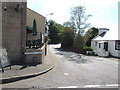
Dailly Road, Crosshill
At the junction with Dalhowan Street.
Image: © Billy McCrorie
Taken: 26 Jul 2012
0.01 miles
4
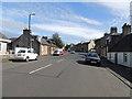
King Street, Crosshill
In the direction of Straiton.
Image: © Billy McCrorie
Taken: 26 Jul 2012
0.01 miles
5
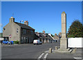
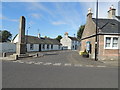
Crosshill War Memorial
The War Memorial was built on the site of the old tollhouse for the turnpike road.
The large building in the background, dated 1897, was the local branch of the Co-op until becoming a private shop in the 1980s. The 3 large windows on the ground floor right show the location of the former shop windows and door.
Image: © Mary and Angus Hogg
Taken: 15 Sep 2006
0.01 miles
7
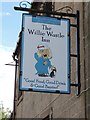
The Willie Wastle Inn, Crosshill
Located on Dalhowan Street.
Image: © Billy McCrorie
Taken: 26 Jul 2012
0.01 miles

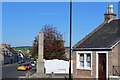
9
Newton Street, Crosshill
From the junctions with King Street and the Dailly Road.
Image: © Billy McCrorie
Taken: 26 Jul 2012
0.02 miles
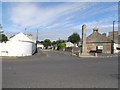
10
Newton Street, Crosshill
From Dalhowan Street.
Image: © Billy McCrorie
Taken: 26 Jul 2012
0.02 miles