IMAGES TAKEN NEAR TO
Kirkbride Crescent, MAYBOLE, KA19 7RQ
Introduction
This page details the photographs taken nearby to Kirkbride Crescent, KA19 7RQ by members of the Geograph project.
The Geograph project started in 2005 with the aim of publishing, organising and preserving representative images for every square kilometre of Great Britain, Ireland and the Isle of Man.

There are currently over 7.5m images from over14,400 individuals and you can help contribute to the project by visiting https://www.geograph.org.uk
Image Map
Images are licensed for reuse under creativecommons.org/licenses/by-sa/2.0
Notes
- Clicking on the map will re-center to the selected point.
- The higher the marker number, the further away the image location is from the centre of the postcode.
Image Listing (192 Images Found)
Images are licensed for reuse under creativecommons.org/licenses/by-sa/2.0
Image
Details
Distance
2
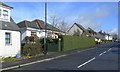
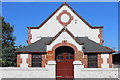
The Former Crosshill Police Office
The house behind the hedge in Kirkmichael Road used to be the village Police Office. The village Bobby and his family lived in the main part of the house. The public office was the smaller part of the building, on the left. There's no village Bobby these days!
Image: © Mary and Angus Hogg
Taken: 8 Mar 2009
0.03 miles
6
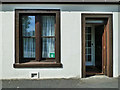
I am OK
The windfarm-funded North Carrick Community Benefit Company set up a resilience group to help local people through the Coronavirus crisis. The green notice in this house window indicates that the residents are all right. The other side of the notice, shown in red, says that help is needed. Local NCCBC volunteers respond quickly to these red notices.
The company also issued every household with printed vouchers to the value of £20, exchangeable to the end of June in a wide range of local shops. This represents an injection of £100,000 into the local community.
Image: © Mary and Angus Hogg
Taken: 22 Apr 2020
0.04 miles
7
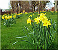
Crosshill Field of Hope
Crosshill's Field of Hope was planted in 2012 in support of the Marie Curie Cancer Care charity. In these days of Coronavirus lockdown, the daffodils are specially symbolic of hope and new growth.
The village play park is shown in the background, out of bounds at present.
Image: © Mary and Angus Hogg
Taken: 10 Apr 2020
0.04 miles
8
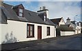
Former Shop In Kirkmichael Road, Crosshill
Many of the older properties in Crosshill have been changed over the years. The non-matching windows on this frontage indicate a change of use. The left hand side of the building, with the larger window, started as a shop. The shop door was on the left of the shop window, where the low-level ventilator is located. The shopkeeper and his family lived in the adjoining house.
Image: © Mary and Angus Hogg
Taken: 4 Mar 2009
0.04 miles
10
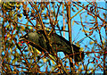
A feasting Jackdaw
The autumn arrival of hungry northern birds promoted a real interest in the Rowan berries. The garden berry crop became steadily depleted, finally cleaned up by some local Jackdaws. The whole process took only about a week. Hawthorn berries are still plentiful but they don’t seem to be as tasty as the Rowans.
Image: © Mary and Angus Hogg
Taken: 2 Nov 2021
0.05 miles