IMAGES TAKEN NEAR TO
Kirkmichael Road, MAYBOLE, KA19 7RJ
Introduction
This page details the photographs taken nearby to Kirkmichael Road, KA19 7RJ by members of the Geograph project.
The Geograph project started in 2005 with the aim of publishing, organising and preserving representative images for every square kilometre of Great Britain, Ireland and the Isle of Man.

There are currently over 7.5m images from over14,400 individuals and you can help contribute to the project by visiting https://www.geograph.org.uk
Image Map
Images are licensed for reuse under creativecommons.org/licenses/by-sa/2.0
Notes
- Clicking on the map will re-center to the selected point.
- The higher the marker number, the further away the image location is from the centre of the postcode.
Image Listing (176 Images Found)
Images are licensed for reuse under creativecommons.org/licenses/by-sa/2.0
Image
Details
Distance
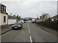
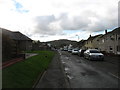
1
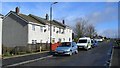
Kirkmichael Road, Crosshill
The top end of Kirkmichael Road, looking out of the village. The houses were replacements for post-war prefabs, which existed into the early 1970s.
Image: © Mary and Angus Hogg
Taken: 8 Mar 2009
0.01 miles
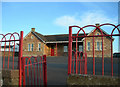
4
Crosshill Nursery
The nursery class was opened as part of the Scottish Executive's Pre-School Education Initiative. Over the years, this building, in the same grounds as the Community Centre, has housed the school gym hall, the school dining hall, the voluntary pre-school playgroup and the youth club.
Image: © Mary and Angus Hogg
Taken: 15 Sep 2006
0.04 miles
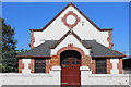
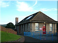
7
Crosshill Community Centre
Crosshill Public School (primary school) originally occupied this building. It was a Continuation School, which provided education up to the age of 14 years for pupils who had not moved on to the Academy in Maybole. Towards the end of the Second World War, the building was used as a Youth Hostel. Most of the visitors came from the Glasgow area.
Image: © Mary and Angus Hogg
Taken: 15 Sep 2006
0.05 miles
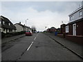
8
Carrick Drive, Crosshill
A small area of Council houses, many of which have been bought by tenants under the Right To Buy scheme.
Image: © Mary and Angus Hogg
Taken: 8 Mar 2009
0.05 miles
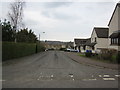
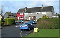
10
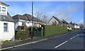
The Former Crosshill Police Office
The house behind the hedge in Kirkmichael Road used to be the village Police Office. The village Bobby and his family lived in the main part of the house. The public office was the smaller part of the building, on the left. There's no village Bobby these days!
Image: © Mary and Angus Hogg
Taken: 8 Mar 2009
0.06 miles