IMAGES TAKEN NEAR TO
Straiton, MAYBOLE, KA19 7QR
Introduction
This page details the photographs taken nearby to KA19 7QR by members of the Geograph project.
The Geograph project started in 2005 with the aim of publishing, organising and preserving representative images for every square kilometre of Great Britain, Ireland and the Isle of Man.

There are currently over 7.5m images from over14,400 individuals and you can help contribute to the project by visiting https://www.geograph.org.uk
Image Map
Images are licensed for reuse under creativecommons.org/licenses/by-sa/2.0
Notes
- Clicking on the map will re-center to the selected point.
- The higher the marker number, the further away the image location is from the centre of the postcode.
Image Listing (9 Images Found)
Images are licensed for reuse under creativecommons.org/licenses/by-sa/2.0
Image
Details
Distance
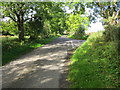
1
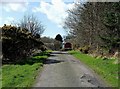
Dyke Farm
The minor road leading to Dyke Farm, near Straiton.
Image: © Mary and Angus Hogg
Taken: 18 Mar 2012
0.01 miles
4
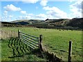
Dyke View
Looking across the valley of the Cawin Burn towards Straiton. In the distance is Craigengower with its famous monument in Image, and Bennan Hill with its distinctive cap of trees in Image These hills mark the start of the Southern Uplands.
Image: © Mary and Angus Hogg
Taken: 18 Mar 2012
0.10 miles
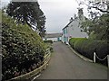
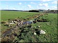
6
Junction of roads near Dyke
Looking south-westward.
Image: © Peter Wood
Taken: 15 Sep 2017
0.12 miles
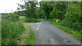
7
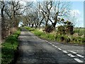
Minor Road Near Straiton
This road connects 4 farms with Straiton and Crosshill.
Image: © Mary and Angus Hogg
Taken: 18 Mar 2012
0.12 miles
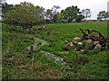
8
A Burn Near Threethorns
This wee burn flows into the Cawin Burn which, in turn, joins the Water of Girvan at Straiton.
Image: © Mary and Angus Hogg
Taken: 18 Mar 2012
0.22 miles
9
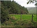
Shelter belt, near Straiton
Looking down into the valley of the Cawin Burn.
Image: © Oliver Dixon
Taken: 17 Oct 2006
0.23 miles