IMAGES TAKEN NEAR TO
Straiton, MAYBOLE, KA19 7QP
Introduction
This page details the photographs taken nearby to KA19 7QP by members of the Geograph project.
The Geograph project started in 2005 with the aim of publishing, organising and preserving representative images for every square kilometre of Great Britain, Ireland and the Isle of Man.

There are currently over 7.5m images from over14,400 individuals and you can help contribute to the project by visiting https://www.geograph.org.uk
Image Map
Images are licensed for reuse under creativecommons.org/licenses/by-sa/2.0
Notes
- Clicking on the map will re-center to the selected point.
- The higher the marker number, the further away the image location is from the centre of the postcode.
Image Listing (6 Images Found)
Images are licensed for reuse under creativecommons.org/licenses/by-sa/2.0
Image
Details
Distance
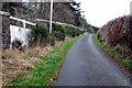
2
Minor road joining the B741 at Girvan Lodge
Looking north-westward.
Image: © Peter Wood
Taken: 15 Sep 2017
0.03 miles
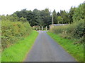
4
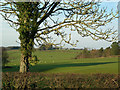
High Garphar
Looking NW from the B741, with the Blairquhan Estate woods on the right and High Garphar Farm on the skyline.
Image: © Mary and Angus Hogg
Taken: 21 Dec 2006
0.16 miles
5
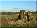
Tree Stump
The remains of an ancient beech tree, with Blairquhan Estate woodland in the background.
Image: © Mary and Angus Hogg
Taken: 21 Dec 2006
0.19 miles