IMAGES TAKEN NEAR TO
Crosshill, MAYBOLE, KA19 7QA
Introduction
This page details the photographs taken nearby to KA19 7QA by members of the Geograph project.
The Geograph project started in 2005 with the aim of publishing, organising and preserving representative images for every square kilometre of Great Britain, Ireland and the Isle of Man.

There are currently over 7.5m images from over14,400 individuals and you can help contribute to the project by visiting https://www.geograph.org.uk
Image Map
Images are licensed for reuse under creativecommons.org/licenses/by-sa/2.0
Notes
- Clicking on the map will re-center to the selected point.
- The higher the marker number, the further away the image location is from the centre of the postcode.
Image Listing (13 Images Found)
Images are licensed for reuse under creativecommons.org/licenses/by-sa/2.0
Image
Details
Distance
1
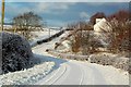
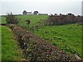
Approaching Threave
Viewed in snowy conditions in late December.
Image: © Mary and Angus Hogg
Taken: 20 Dec 2009
0.01 miles
2
Approaching Threave Farm
For a similar view in different conditions, see Image which was taken in December 2009 at the start of the first ”Big Freeze” of 2010. The round trip from Crosshill village, known locally as “going round The Rink”, has become popular during the Coronavirus restrictions.
Image: © Mary and Angus Hogg
Taken: 20 Apr 2020
0.01 miles
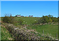
3
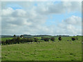
Threave Farm viewed again
A January view showing the land with a light cover of snow. For a spring view of this scene, see Image
Image: © Mary and Angus Hogg
Taken: 8 Jan 2021
0.02 miles
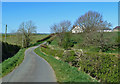
4
Threave Farm view
Viewed from the Crosshill to Kirkmichael road on a lovely late-April afternoon.
Image: © Mary and Angus Hogg
Taken: 21 Apr 2020
0.02 miles
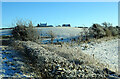
6
Threave View
Looking towards Threave Farm from Crosshill, with Barskelly in the distance. This area's landscape comes from deposition during the last Ice Age.
Image: © Mary and Angus Hogg
Taken: 12 Oct 2006
0.07 miles
7
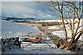
Towards Kildoon Hill
Viewed in wintry conditions from the minor road near Threave Farm, with Kildoon Hill on the skyline.
Image: © Mary and Angus Hogg
Taken: 20 Dec 2009
0.11 miles
8
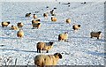
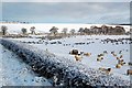
Natural Insulation
Sheep must be very well insulated to stay out in such cold weather.
Image: © Mary and Angus Hogg
Taken: 20 Dec 2009
0.11 miles
9
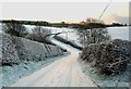
Going Round The Rigg
This minor road near Crosshill is part of a circuit known as "going round the Rigg". It's a popular walk for dog-owners.
Image: © Mary and Angus Hogg
Taken: 20 Dec 2009
0.12 miles
10
Snowy South Ayrshire
It's unusual to see so much snow at low level in South Ayrshire. This shot was taken in late December after a fall of about 4cm, with more to come.
Image: © Mary and Angus Hogg
Taken: 20 Dec 2009
0.12 miles