IMAGES TAKEN NEAR TO
Crosshill, MAYBOLE, KA19 7PT
Introduction
This page details the photographs taken nearby to KA19 7PT by members of the Geograph project.
The Geograph project started in 2005 with the aim of publishing, organising and preserving representative images for every square kilometre of Great Britain, Ireland and the Isle of Man.

There are currently over 7.5m images from over14,400 individuals and you can help contribute to the project by visiting https://www.geograph.org.uk
Image Map
Images are licensed for reuse under creativecommons.org/licenses/by-sa/2.0
Notes
- Clicking on the map will re-center to the selected point.
- The higher the marker number, the further away the image location is from the centre of the postcode.
Image Listing (196 Images Found)
Images are licensed for reuse under creativecommons.org/licenses/by-sa/2.0
Image
Details
Distance
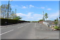
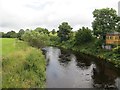
1
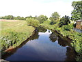
Water of Girvan at Crosshill
Looking upstream from the Crosshill bridge.
Image: © Billy McCrorie
Taken: 26 Jul 2012
0.01 miles
4
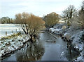
Ice forming on the Water of Girvan
There was no ice on the river during the 2020-21 cold snap up to the last night when it started to form on the slower-flowing water. It's easy to forget what previous cold spells were like. Image gives a good reminder of conditions during the Big Freeze of 2009-10.
Image: © Mary and Angus Hogg
Taken: 9 Jan 2021
0.02 miles
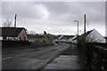
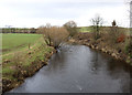
5
Water of Girvan
From the bridge at Crosshill after rain.
Image: © Richard Webb
Taken: 13 Aug 2014
0.03 miles