IMAGES TAKEN NEAR TO
Burnside Row, MAYBOLE, KA19 7PL
Introduction
This page details the photographs taken nearby to Burnside Row, KA19 7PL by members of the Geograph project.
The Geograph project started in 2005 with the aim of publishing, organising and preserving representative images for every square kilometre of Great Britain, Ireland and the Isle of Man.

There are currently over 7.5m images from over14,400 individuals and you can help contribute to the project by visiting https://www.geograph.org.uk
Image Map
Images are licensed for reuse under creativecommons.org/licenses/by-sa/2.0
Notes
- Clicking on the map will re-center to the selected point.
- The higher the marker number, the further away the image location is from the centre of the postcode.
Image Listing (161 Images Found)
Images are licensed for reuse under creativecommons.org/licenses/by-sa/2.0
Image
Details
Distance
1
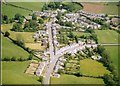
Kirkmichael village from the air
Taken in the month of June from a point west of the village.
Image: © Paul Ravenscroft
Taken: Unknown
0.02 miles
3
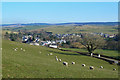
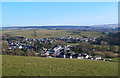
Kirkmichael Village View
A large part of Kirkmichael is shown in this view, taken from the road to Drumore Farm. The village lies in the valley of the Dyrock Burn, in a lowland glacial landscape. The small rolling hills are drumlins, laid down by the moving ice sheet.
Image: © Mary and Angus Hogg
Taken: 28 Feb 2013
0.03 miles
4
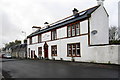
McClure House on the Patna Road
Now sporting solar panels
Image: © Philip Jeffrey
Taken: 30 Dec 2012
0.03 miles
5
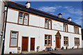
Maclure House, Patna Road, Kirkmichael
Formerly the Maclure Inn
Image: © Leslie Barrie
Taken: 29 Sep 2013
0.04 miles
6
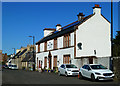
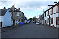
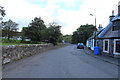
Patna Road
Maclure House, formerly the Maclure Inn, viewed on a lovely spring morning.
Image: © Mary and Angus Hogg
Taken: 16 May 2018
0.04 miles
8
Kirkmichael Village View
Most of Kirkmichael is shown in this view, taken from the road to Drumore Farm. The village lies in the valley of the Dyrock Burn, in a lowland glacial landscape. The small rolling hills are drumlins, laid down by the moving ice sheet. The wood on the far right is growing on an esker, a long ridge of sand and gravel produced by water flowing below the melting ice sheet. The esker extends into the next square.
Image: © Mary and Angus Hogg
Taken: 28 Feb 2013
0.05 miles