IMAGES TAKEN NEAR TO
Newton Stewart Road, MAYBOLE, KA19 7NH
Introduction
This page details the photographs taken nearby to Newton Stewart Road, KA19 7NH by members of the Geograph project.
The Geograph project started in 2005 with the aim of publishing, organising and preserving representative images for every square kilometre of Great Britain, Ireland and the Isle of Man.

There are currently over 7.5m images from over14,400 individuals and you can help contribute to the project by visiting https://www.geograph.org.uk
Image Map
Images are licensed for reuse under creativecommons.org/licenses/by-sa/2.0
Notes
- Clicking on the map will re-center to the selected point.
- The higher the marker number, the further away the image location is from the centre of the postcode.
Image Listing (200 Images Found)
Images are licensed for reuse under creativecommons.org/licenses/by-sa/2.0
Image
Details
Distance


4

Approaching Straiton
From the Glentrool road.
Image: © Billy McCrorie
Taken: 13 Jul 2012
0.04 miles
5

Straiton War Memorial
A Celtic cross in Main Street Image
Image: © Walter Baxter
Taken: 22 Sep 2008
0.04 miles
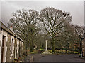
6

The war memorial, Straiton
The focal point at the end of the main street.
Image: © Humphrey Bolton
Taken: 22 Sep 2011
0.05 miles
7

Sunbeams over the War Memorial
The Straiton War Memorial stands at the end of Main Street. The photograph was taken looking directly into the sun.
Image: © Ann Cook
Taken: 15 Apr 2012
0.05 miles

10

Straiton Village
A small village with houses typical of the area.
Image: © Malcolm Neal
Taken: 18 Mar 2022
0.06 miles