IMAGES TAKEN NEAR TO
Straiton, MAYBOLE, KA19 7NB
Introduction
This page details the photographs taken nearby to KA19 7NB by members of the Geograph project.
The Geograph project started in 2005 with the aim of publishing, organising and preserving representative images for every square kilometre of Great Britain, Ireland and the Isle of Man.

There are currently over 7.5m images from over14,400 individuals and you can help contribute to the project by visiting https://www.geograph.org.uk
Image Map
Images are licensed for reuse under creativecommons.org/licenses/by-sa/2.0
Notes
- Clicking on the map will re-center to the selected point.
- The higher the marker number, the further away the image location is from the centre of the postcode.
Image Listing (117 Images Found)
Images are licensed for reuse under creativecommons.org/licenses/by-sa/2.0
Image
Details
Distance
1
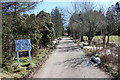
Bennan Stables, Straiton
Conversion of one of the farm buildings to form living accommodation.
Image: © wfmillar
Taken: 14 Apr 2007
0.03 miles
2
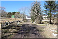
Monument - Bennan Circuit
Passing Bennan farm.
Image: © Billy McCrorie
Taken: 3 Apr 2013
0.05 miles
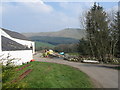
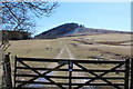
5
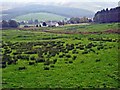
Bennan Stud, near Straiton
The village can be seen in the distance Image
Image: © Oliver Dixon
Taken: 17 Oct 2006
0.07 miles
8
Monument - Bennan Circuit
Passing Stepends.
Image: © Billy McCrorie
Taken: 3 Apr 2013
0.08 miles
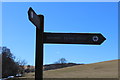
9
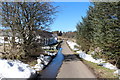
Bennan Walk
With view towards Bennan hill.
Image: © Billy McCrorie
Taken: 3 Apr 2013
0.09 miles
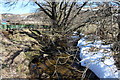
10
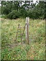
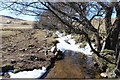
Portable stile, Straiton
It would be useful to have a lightweight foldable version of this!
Image: © Humphrey Bolton
Taken: 22 Sep 2011
0.12 miles