IMAGES TAKEN NEAR TO
MAYBOLE, KA19 7LX
Introduction
This page details the photographs taken nearby to KA19 7LX by members of the Geograph project.
The Geograph project started in 2005 with the aim of publishing, organising and preserving representative images for every square kilometre of Great Britain, Ireland and the Isle of Man.

There are currently over 7.5m images from over14,400 individuals and you can help contribute to the project by visiting https://www.geograph.org.uk
Image Map (Loading...)


Getting Data...Please wait
Leaflet Map data © OpenStreetMap
Images are licensed for reuse under creativecommons.org/licenses/by-sa/2.0
Notes
- Clicking on the map will re-center to the selected point.
- The higher the marker number, the further away the image location is from the centre of the postcode.
Image Listing (19 Images Found)
Images are licensed for reuse under creativecommons.org/licenses/by-sa/2.0
Image
Details
Distance
2
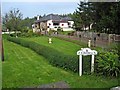
Glenlea, near Straiton
The garden of this bungalow is filled with statues and water features erected by the owner, one of which commemorates her father. Not to everybody's taste, however.
Image: © Oliver Dixon
Taken: 17 Oct 2006
0.02 miles
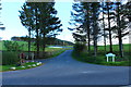


9
Balminnoch Farm
You can just see the monument on the hill above Straiton.
Image: © Billy McCrorie
Taken: 23 Oct 2016
0.11 miles