IMAGES TAKEN NEAR TO
MAYBOLE, KA19 7LP
Introduction
This page details the photographs taken nearby to KA19 7LP by members of the Geograph project.
The Geograph project started in 2005 with the aim of publishing, organising and preserving representative images for every square kilometre of Great Britain, Ireland and the Isle of Man.

There are currently over 7.5m images from over14,400 individuals and you can help contribute to the project by visiting https://www.geograph.org.uk
Image Map
Images are licensed for reuse under creativecommons.org/licenses/by-sa/2.0
Notes
- Clicking on the map will re-center to the selected point.
- The higher the marker number, the further away the image location is from the centre of the postcode.
Image Listing (7 Images Found)
Images are licensed for reuse under creativecommons.org/licenses/by-sa/2.0
Image
Details
Distance
1
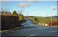
Harkieston Bridge
This bridge crosses Chapelton Burn. The sign post tells us that it's 8½ miles to Ayr and 1½ to Maybole. The house on the left is on the site of an old smiddy.
Image: © Mary and Angus Hogg
Taken: 8 Feb 2015
0.03 miles
2

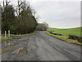
Old Direction sign - Signpost by the B7045, Harkieston Bridge, Maybole parish
Annulus finial - 3 arms; by the B7045, Harkieston Bridge, in parish of Maybole (East Ayrshire District), East of Maybole.
Surveyed
Milestone Society National ID: AY_NS3210
Image: © Milestone Society
Taken: Unknown
0.04 miles
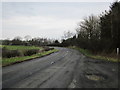
3
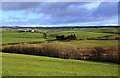
B7045 near Grimmet
In the direction of Kirkmichael.
Image: © Billy McCrorie
Taken: 12 Feb 2013
0.20 miles
4
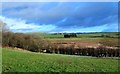
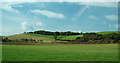
Chapelton Loch View
A winter view of classic drumlin country in South Ayrshire. Often described as a "basket of eggs", the low mounds were deposited by ice sheets during the last glaciation. The land between them is often wet. Chapelton Loch, shown in the foreground, is a large marshy area. It is believed to mark the former course of the River Girvan which was completely re-routed by the glacial deposits.
Image: © Mary and Angus Hogg
Taken: 30 Jan 2015
0.21 miles
5
Chapelton Loch and Marsh
Chapelton Loch is believed to be part of an old watercourse that carried the River Girvan to join the River Doon towards the end of the last Ice Age. Previous attempts to drain this area were abandoned but the loch often dries out considerably during dry summer weather. The surrounding land is shaped by drumlins, also created during the Ice Age.
Image: © Mary and Angus Hogg
Taken: 30 Jan 2015
0.22 miles
6
B7045 near Grimmet
In the Minishant direction.
Image: © Billy McCrorie
Taken: 12 Feb 2013
0.22 miles
7
Chapelton Loch
Glacial sink hole with reedbed surrounding small loch. Attempts to drain this in recent years have failed, despite the use of a small pump-house.
Image: © Mary and Angus Hogg
Taken: 19 Sep 2006
0.24 miles