IMAGES TAKEN NEAR TO
MAYBOLE, KA19 7LF
Introduction
This page details the photographs taken nearby to KA19 7LF by members of the Geograph project.
The Geograph project started in 2005 with the aim of publishing, organising and preserving representative images for every square kilometre of Great Britain, Ireland and the Isle of Man.

There are currently over 7.5m images from over14,400 individuals and you can help contribute to the project by visiting https://www.geograph.org.uk
Image Map
Images are licensed for reuse under creativecommons.org/licenses/by-sa/2.0
Notes
- Clicking on the map will re-center to the selected point.
- The higher the marker number, the further away the image location is from the centre of the postcode.
Image Listing (4 Images Found)
Images are licensed for reuse under creativecommons.org/licenses/by-sa/2.0
Image
Details
Distance
1
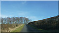
Hedges and trees not yet in leaf
Heading along another minor road on this bright early spring day with none of the trees or shrubs yet in leaf.
Image: © Malcolm Neal
Taken: 18 Mar 2022
0.12 miles
2
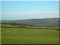
View from Guiltree Hill
Looking ENE from the West of Scotland Water building. Barnshean Loch is just visible in the distance.
Image: © Mary and Angus Hogg
Taken: 26 Nov 2006
0.23 miles
3
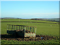
Livestock Feeder
Looking NE from the West of Scotland Water building on Guiltree Hill.
Image: © Mary and Angus Hogg
Taken: 26 Nov 2006
0.23 miles
4
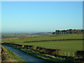
Towards Ballycoach
Going down the north side of Guiltree Hill on a fine November morning.
Image: © Mary and Angus Hogg
Taken: 26 Nov 2006
0.23 miles