IMAGES TAKEN NEAR TO
MAYBOLE, KA19 7LA
Introduction
This page details the photographs taken nearby to KA19 7LA by members of the Geograph project.
The Geograph project started in 2005 with the aim of publishing, organising and preserving representative images for every square kilometre of Great Britain, Ireland and the Isle of Man.

There are currently over 7.5m images from over14,400 individuals and you can help contribute to the project by visiting https://www.geograph.org.uk
Image Map
Images are licensed for reuse under creativecommons.org/licenses/by-sa/2.0
Notes
- Clicking on the map will re-center to the selected point.
- The higher the marker number, the further away the image location is from the centre of the postcode.
Image Listing (8 Images Found)
Images are licensed for reuse under creativecommons.org/licenses/by-sa/2.0
Image
Details
Distance
1
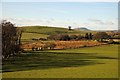
Cairnhill View
A winter view of South Ayrshire's rolling farmland on ground that was deposited by the last ice sheets. Goose Hill, in the next square, is a drumlin lying behind the small boggy area that is typical of this landscape. The well-known local landmark of Mochrum Hill is shown on the skyline.
Image: © Mary and Angus Hogg
Taken: 1 Feb 2015
0.15 miles
2
Cairnhill Farm
Located in South Ayrshire's rolling drumlin country, the name of the farm suggests that a cairn should exist nearby. I couldn't find anything definite, not even on Cairn Hill, but sometimes years of agricultural improvements can mask these old sites.
Image: © Mary and Angus Hogg
Taken: 1 Feb 2015
0.16 miles
3
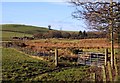
Could This Be An Old Cairn?
The name of Cairnhill Farm suggests that a cairn should exist nearby. I couldn't find anything definite, not even on Cairn Hill, but sometimes years of agricultural improvements can mask these old sites. I did wonder about the heap of boulders shown here as this sort of feature often indicates an ancient cairn.
Image: © Mary and Angus Hogg
Taken: 1 Feb 2015
0.22 miles
4
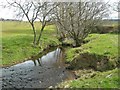
Spallander Burn
Viewed just before it flows into the Dyrock Burn.
Image: © Mary and Angus Hogg
Taken: 20 Apr 2008
0.23 miles
5

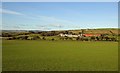
Towards Glenside Farm
A mid-winter view of South Ayrshire's rolling farmland, looking towards Glenside Farm, which lies in the next square. The rolling countryside comes from drumlins which were deposited during the last Ice Age.
Image: © Mary and Angus Hogg
Taken: 4 Jan 2015
0.23 miles
6

Towards Dyrockbank
Looking towards Dyrockbank from the Glenside Farm access road on a chilly January morning.
Image: © Mary and Angus Hogg
Taken: 4 Jan 2015
0.23 miles
7

Muirsmill Burn
Muirsmill Burn is in the Water of Girvan's catchment area. Viewed in mid-winter after a long period of wet weather.
Image: © Mary and Angus Hogg
Taken: 4 Jan 2015
0.23 miles
8
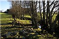
Trees by Spallander Burn
A winter view looking upstream. The burn flows from Loch Spallander to the Dyrock Burn, which eventually joins the River Girvan.
Image: © Mary and Angus Hogg
Taken: 1 Feb 2015
0.23 miles