IMAGES TAKEN NEAR TO
MAYBOLE, KA19 7JZ
Introduction
This page details the photographs taken nearby to KA19 7JZ by members of the Geograph project.
The Geograph project started in 2005 with the aim of publishing, organising and preserving representative images for every square kilometre of Great Britain, Ireland and the Isle of Man.

There are currently over 7.5m images from over14,400 individuals and you can help contribute to the project by visiting https://www.geograph.org.uk
Image Map
Images are licensed for reuse under creativecommons.org/licenses/by-sa/2.0
Notes
- Clicking on the map will re-center to the selected point.
- The higher the marker number, the further away the image location is from the centre of the postcode.
Image Listing (3 Images Found)
Images are licensed for reuse under creativecommons.org/licenses/by-sa/2.0
Image
Details
Distance
2
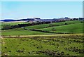
South Ayrshire Farmland View
The rolling farmland is made from drumlins which were deposited during the last Ice Age. They provide heavy, sticky clay soils that hold a lot of water but which support good grassland. The farms are Troquhain on the left and Glenside on the right.
Image: © Mary and Angus Hogg
Taken: 1 Feb 2015
0.17 miles
3
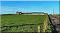
Goosehill Farm
Located on a drumlin in South Ayrshire's rolling pastureland.
Image: © Mary and Angus Hogg
Taken: 1 Feb 2015
0.22 miles