IMAGES TAKEN NEAR TO
Kirkmichael, MAYBOLE, KA19 7JY
Introduction
This page details the photographs taken nearby to KA19 7JY by members of the Geograph project.
The Geograph project started in 2005 with the aim of publishing, organising and preserving representative images for every square kilometre of Great Britain, Ireland and the Isle of Man.

There are currently over 7.5m images from over14,400 individuals and you can help contribute to the project by visiting https://www.geograph.org.uk
Image Map
Images are licensed for reuse under creativecommons.org/licenses/by-sa/2.0
Notes
- Clicking on the map will re-center to the selected point.
- The higher the marker number, the further away the image location is from the centre of the postcode.
Image Listing (7 Images Found)
Images are licensed for reuse under creativecommons.org/licenses/by-sa/2.0
Image
Details
Distance
1
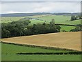
Barley, Roaston
A barley field stands out amongst the usual grass fields.
Image: © Richard Webb
Taken: 13 Aug 2014
0.06 miles
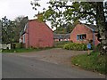
3
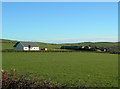
Mossend Farm
Rich farmland on glacial deposits.
Image: © Mary and Angus Hogg
Taken: 26 Nov 2006
0.10 miles
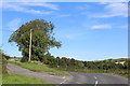
4
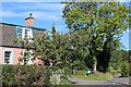
Mossend Cottage
Mossend Cottage in crisp November sunshine, with the minor road snaking up towards Guiltreehill in the background.
Image: © Mary and Angus Hogg
Taken: 26 Nov 2006
0.10 miles
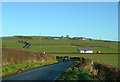
7
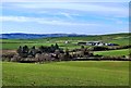
Towards Mossend
Looking towards Mossend Farm from a large drumlin on the south side of the Dyrock Burn.
Image: © Mary and Angus Hogg
Taken: 21 Mar 2015
0.21 miles