IMAGES TAKEN NEAR TO
Glebe Crescent, MAYBOLE, KA19 7HZ
Introduction
This page details the photographs taken nearby to Glebe Crescent, KA19 7HZ by members of the Geograph project.
The Geograph project started in 2005 with the aim of publishing, organising and preserving representative images for every square kilometre of Great Britain, Ireland and the Isle of Man.

There are currently over 7.5m images from over14,400 individuals and you can help contribute to the project by visiting https://www.geograph.org.uk
Image Map
Images are licensed for reuse under creativecommons.org/licenses/by-sa/2.0
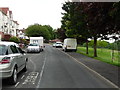
Notes
- Clicking on the map will re-center to the selected point.
- The higher the marker number, the further away the image location is from the centre of the postcode.
Image Listing (337 Images Found)
Images are licensed for reuse under creativecommons.org/licenses/by-sa/2.0
Image
Details
Distance
2
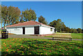
The Sommerville Pavilion
The Sommerville Pavilion at Maybole’s Glebe Park was opened in 1995 and relaunched in 2018 after refurbishment and development for the North Carrick Sports Hub. The project was well supported by local community groups and the new rugby goals are a prominent feature of the site. The pavilion lies on the edge of this square.
Image: © Mary and Angus Hogg
Taken: 10 Oct 2018
0.03 miles
3
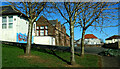
Cairn Primary School
Maybole’s oldest primary school was closed in 2023 when it merged with Gardenrose PS to form the new Culzean Primary School in Maybole Community Campus. See Image Now redundant, this spacious site is expected to be used for housing.
Image: © Mary and Angus Hogg
Taken: 6 Mar 2022
0.04 miles
5
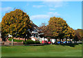
Autumn Colours at Glebe Crescent
The houses overlook The Glebe, a popular recreational area on the edge of Maybole. A mid-October view with the trees showing good autumn tints.
Image: © Mary and Angus Hogg
Taken: 16 Oct 2014
0.05 miles
6
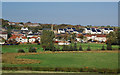
Maybole View
Looking towards Maybole from Tunnoch Farm on a lovely October morning. Being built on a hill, the town's residents enjoy good views. From the left, this shot shows The Glebe with its playing fields and park, houses on Glebe Crescent, the old church on Cassillis Road Image, the Sommerville Pavilion Image and the new housing at Jack's Gait Image Most of the buildings lie in the next square.
Image: © Mary and Angus Hogg
Taken: 10 Oct 2018
0.05 miles
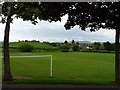
7
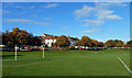
Maybole Glebe
The Glebe is a popular recreational area on the edge of Maybole. This mid-October view shows the trees with good autumn colours. A glebe was a piece of land attached to a church minister's house.
Image: © Mary and Angus Hogg
Taken: 16 Oct 2014
0.05 miles
8
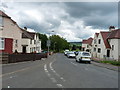
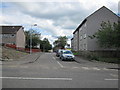
Glebe Crescent
From the junction with Cairnfield Avenue.
Image: © Billy McCrorie
Taken: 13 Jun 2012
0.05 miles
9
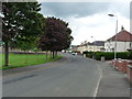
Glebe Crescent
Going towards the Crosshill road.
Image: © Billy McCrorie
Taken: 13 Jun 2012
0.06 miles
10
Swan Court
Swan Court from the junction with Kirkland Rd.
Image: © Billy McCrorie
Taken: 25 Aug 2011
0.06 miles