IMAGES TAKEN NEAR TO
Sunnyside, Cassillis Road, MAYBOLE, KA19 7HH
Introduction
This page details the photographs taken nearby to Sunnyside, Cassillis Road, KA19 7HH by members of the Geograph project.
The Geograph project started in 2005 with the aim of publishing, organising and preserving representative images for every square kilometre of Great Britain, Ireland and the Isle of Man.

There are currently over 7.5m images from over14,400 individuals and you can help contribute to the project by visiting https://www.geograph.org.uk
Image Map
Images are licensed for reuse under creativecommons.org/licenses/by-sa/2.0
Notes
- Clicking on the map will re-center to the selected point.
- The higher the marker number, the further away the image location is from the centre of the postcode.
Image Listing (92 Images Found)
Images are licensed for reuse under creativecommons.org/licenses/by-sa/2.0
Image
Details
Distance
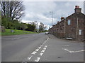
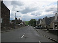
1
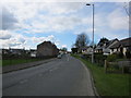
Cassillis Road
Heading for Maybole town centre.
Image: © Billy McCrorie
Taken: 24 Apr 2012
0.02 miles
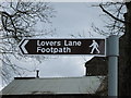
2
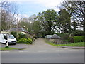
Lovers Lane
Start of the Lovers Lane Footpath from the Cassillis Road.
Image: © Billy McCrorie
Taken: 24 Apr 2012
0.03 miles
4
Lovers Lane
Looking back towards the Cassillis Road.
Image: © Billy McCrorie
Taken: 24 Apr 2012
0.04 miles
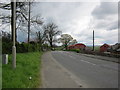
5
Cassillis Road
From the junction with the Kirkmichael Road heading for Ayr.
Image: © Billy McCrorie
Taken: 24 Apr 2012
0.05 miles
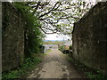
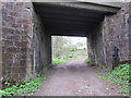
6
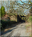
The Start of Lovers' Lane
Viewed on a bright early-January afternoon where the track passes underneath the railway line.
Image: © Mary and Angus Hogg
Taken: 9 Jan 2019
0.05 miles
7
Cassillis Road (A77)
From the junction with Lovers Lane heading towards Ayr.
Image: © Billy McCrorie
Taken: 24 Apr 2012
0.05 miles
8
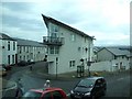
Maybole town
A snatched shot travelling through the area.
Image: © Kenneth Allen
Taken: 15 Sep 2007
0.06 miles
9
Lovers Lane
Going under the railway bridge.
Image: © Billy McCrorie
Taken: 24 Apr 2012
0.06 miles
10
Kirkmichael Road
From the junction with the Cassillis Road heading for Kirkmichael and Straiton.
Image: © Billy McCrorie
Taken: 24 Apr 2012
0.06 miles