IMAGES TAKEN NEAR TO
Greenside, MAYBOLE, KA19 7DG
Introduction
This page details the photographs taken nearby to Greenside, KA19 7DG by members of the Geograph project.
The Geograph project started in 2005 with the aim of publishing, organising and preserving representative images for every square kilometre of Great Britain, Ireland and the Isle of Man.

There are currently over 7.5m images from over14,400 individuals and you can help contribute to the project by visiting https://www.geograph.org.uk
Image Map
Images are licensed for reuse under creativecommons.org/licenses/by-sa/2.0
Notes
- Clicking on the map will re-center to the selected point.
- The higher the marker number, the further away the image location is from the centre of the postcode.
Image Listing (468 Images Found)
Images are licensed for reuse under creativecommons.org/licenses/by-sa/2.0
Image
Details
Distance
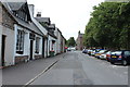
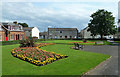
3
The Greenside Pub
Viewed from the town gardens.
Image: © Billy McCrorie
Taken: 13 Jul 2011
0.01 miles
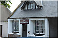
6
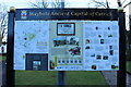
History of Maybole
The Timeline on the right starts at 1193.
Image: © Billy McCrorie
Taken: 1 Feb 2018
0.01 miles
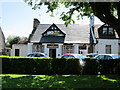
8
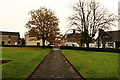
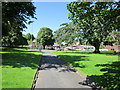
Wide Open Spaces in Maybole Town Green
The gardens in the town green have been opened up after the felling of a mature weeping elm tree. Image shows what the Green looked like in 2006 before the tree started to die.
Image: © Mary and Angus Hogg
Taken: 21 Aug 2015
0.02 miles
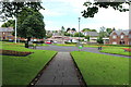
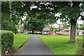
10
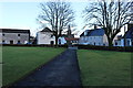
Town Gardens
Gardens located on Greenside at the Railway Station.
Image: © Billy McCrorie
Taken: 13 Jul 2011
0.02 miles