IMAGES TAKEN NEAR TO
Dailly Road, MAYBOLE, KA19 7AX
Introduction
This page details the photographs taken nearby to Dailly Road, KA19 7AX by members of the Geograph project.
The Geograph project started in 2005 with the aim of publishing, organising and preserving representative images for every square kilometre of Great Britain, Ireland and the Isle of Man.

There are currently over 7.5m images from over14,400 individuals and you can help contribute to the project by visiting https://www.geograph.org.uk
Image Map
Images are licensed for reuse under creativecommons.org/licenses/by-sa/2.0
Notes
- Clicking on the map will re-center to the selected point.
- The higher the marker number, the further away the image location is from the centre of the postcode.
Image Listing (49 Images Found)
Images are licensed for reuse under creativecommons.org/licenses/by-sa/2.0
Image
Details
Distance
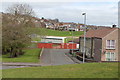
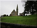
1
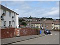
Dailly Road, Maybole
Looking towards the town centre.
Image: © Richard Webb
Taken: 13 Aug 2014
0.02 miles
6
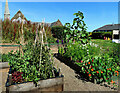
Carrick Community Food Garden
Carrick Community Food Garden was established in Maybole at the start of 2022 on the old car park for Our Lady & St Cuthbert’s Church. It has proved to be highly productive and there’s still space for flowers that attract bees and butterflies.
Image: © Mary and Angus Hogg
Taken: 10 Aug 2022
0.08 miles
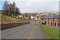
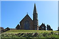
10
Maybole Church
Taken from Miller Terrace.
Image: © Billy McCrorie
Taken: 23 Feb 2012
0.09 miles