IMAGES TAKEN NEAR TO
KA18 4YE
Introduction
This page details the photographs taken nearby to KA18 4YE by members of the Geograph project.
The Geograph project started in 2005 with the aim of publishing, organising and preserving representative images for every square kilometre of Great Britain, Ireland and the Isle of Man.

There are currently over 7.5m images from over14,400 individuals and you can help contribute to the project by visiting https://www.geograph.org.uk
Image Map
Images are licensed for reuse under creativecommons.org/licenses/by-sa/2.0
Notes
- Clicking on the map will re-center to the selected point.
- The higher the marker number, the further away the image location is from the centre of the postcode.
Image Listing (12 Images Found)
Images are licensed for reuse under creativecommons.org/licenses/by-sa/2.0
Image
Details
Distance
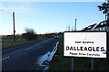
3
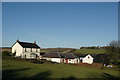
Dalleagles Terrace
The tiny settlement of Dalleagles on the B741 between New Cumnock and Dalmellington.
Image: © Mary and Angus Hogg
Taken: 11 Oct 2020
0.03 miles
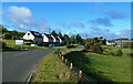
4
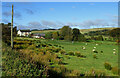
Dalleagles view
Improved grazing land in the foreground and restored open-cast mines on the skyline.
Image: © Mary and Angus Hogg
Taken: 11 Oct 2020
0.05 miles
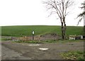
8
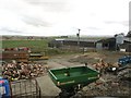
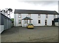
Straid farmyard
This farmyard is on the opposite side of the B741 from the farmhouse.
Image: © Ann Cook
Taken: 15 May 2013
0.17 miles
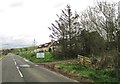
9
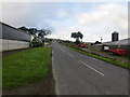
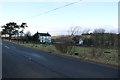
Road (B741) at Straid Farm
Looking south-westward.
Image: © Peter Wood
Taken: 16 Sep 2016
0.19 miles