IMAGES TAKEN NEAR TO
New Cumnock, CUMNOCK, KA18 4QR
Introduction
This page details the photographs taken nearby to KA18 4QR by members of the Geograph project.
The Geograph project started in 2005 with the aim of publishing, organising and preserving representative images for every square kilometre of Great Britain, Ireland and the Isle of Man.

There are currently over 7.5m images from over14,400 individuals and you can help contribute to the project by visiting https://www.geograph.org.uk
Image Map
Images are licensed for reuse under creativecommons.org/licenses/by-sa/2.0
Notes
- Clicking on the map will re-center to the selected point.
- The higher the marker number, the further away the image location is from the centre of the postcode.
Image Listing (5 Images Found)
Images are licensed for reuse under creativecommons.org/licenses/by-sa/2.0
Image
Details
Distance
1
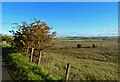
Moorland view
An early-autumn view looking over the moss towards the new loch that's been created by the open-cast restoration. The road from Dalleagles ends just round the corner.
Image: © Mary and Angus Hogg
Taken: 11 Oct 2020
0.18 miles
2
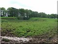
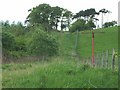
Muddy Gateway
This is an old Pit head as detailed on the O/S 1:25000 series maps.
Image: © Stuart Brabbs
Taken: 14 May 2007
0.19 miles
3
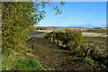
The end of the road
The road between Dalleagles and Cumnock, which was cut off by open-cast mining developments, is still closed but there are signs of possible reinstatement with the restoration work. For an earlier view, see Image
Image: © Mary and Angus Hogg
Taken: 11 Oct 2020
0.20 miles
4
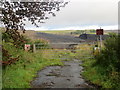
The road from Dalleagles to Benston has been lost to Opencast Workings
Looking northward.
Image: © Peter Wood
Taken: 16 Sep 2016
0.22 miles
5
Old Farm road.
A new entrance to the farm is just south of this position. I would think it was moved due to its location on a blind summit.
Image: © Stuart Brabbs
Taken: 14 May 2007
0.25 miles