IMAGES TAKEN NEAR TO
Mansefield Court, CUMNOCK, KA18 4NY
Introduction
This page details the photographs taken nearby to Mansefield Court, KA18 4NY by members of the Geograph project.
The Geograph project started in 2005 with the aim of publishing, organising and preserving representative images for every square kilometre of Great Britain, Ireland and the Isle of Man.

There are currently over 7.5m images from over14,400 individuals and you can help contribute to the project by visiting https://www.geograph.org.uk
Image Map
Images are licensed for reuse under creativecommons.org/licenses/by-sa/2.0
Notes
- Clicking on the map will re-center to the selected point.
- The higher the marker number, the further away the image location is from the centre of the postcode.
Image Listing (7 Images Found)
Images are licensed for reuse under creativecommons.org/licenses/by-sa/2.0
Image
Details
Distance
3
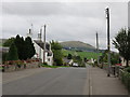
Mansfield Road, New Cumnock
Houses at Mansfield with Pathhead in the distance
Image: © Robert Guthrie
Taken: 31 Dec 2004
0.09 miles
4

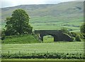
Putting stripes on it.
Rolling the fields. Pathhead is just beyond.
Image: © Stuart Brabbs
Taken: 15 May 2007
0.20 miles
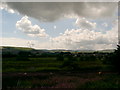
5
Looking down the Nith Valley
Taken from just outside Pathhead looking south east along the Nith Valley.
Image: © Stuart Brabbs
Taken: 15 May 2007
0.20 miles
6
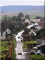
New Cumnock
This photo was taken from Muirfoot Place, overlooking the railway line. New Cumnock station and the Nith Bridge are just behind the trees on the right, and the town itself can be seen in the middle distance.
Image: © L J Cunningham
Taken: 27 Jul 2006
0.22 miles
7
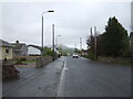
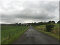
Pathhead
A minor road towards Mansfield Mains.
Image: © JThomas
Taken: 21 May 2021
0.24 miles