IMAGES TAKEN NEAR TO
New Cumnock, CUMNOCK, KA18 4NT
Introduction
This page details the photographs taken nearby to KA18 4NT by members of the Geograph project.
The Geograph project started in 2005 with the aim of publishing, organising and preserving representative images for every square kilometre of Great Britain, Ireland and the Isle of Man.

There are currently over 7.5m images from over14,400 individuals and you can help contribute to the project by visiting https://www.geograph.org.uk
Image Map (Loading...)


Getting Data...Please wait
Leaflet Map data © OpenStreetMap
Images are licensed for reuse under creativecommons.org/licenses/by-sa/2.0
Notes
- Clicking on the map will re-center to the selected point.
- The higher the marker number, the further away the image location is from the centre of the postcode.
Image Listing (2 Images Found)
Images are licensed for reuse under creativecommons.org/licenses/by-sa/2.0
Image
Details
Distance
1
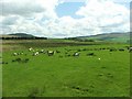
Looking towards Roughside.
I can imagine how remote this must feel in mid winter.
Image: © Stuart Brabbs
Taken: 15 May 2007
0.08 miles
2
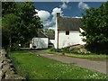
Roughside Farm House
There is foot access only between here and Polquheys.
I met the farmer and chatted for a while. The water supply to his fields has dried up due to the opencast uphill. He is assured that it will come back once the site is completed so until then, as he says, "They're supping council water!"
Image: © Stuart Brabbs
Taken: 15 May 2007
0.09 miles