IMAGES TAKEN NEAR TO
Lime Road, CUMNOCK, KA18 4JW
Introduction
This page details the photographs taken nearby to Lime Road, KA18 4JW by members of the Geograph project.
The Geograph project started in 2005 with the aim of publishing, organising and preserving representative images for every square kilometre of Great Britain, Ireland and the Isle of Man.

There are currently over 7.5m images from over14,400 individuals and you can help contribute to the project by visiting https://www.geograph.org.uk
Image Map
Images are licensed for reuse under creativecommons.org/licenses/by-sa/2.0
Notes
- Clicking on the map will re-center to the selected point.
- The higher the marker number, the further away the image location is from the centre of the postcode.
Image Listing (21 Images Found)
Images are licensed for reuse under creativecommons.org/licenses/by-sa/2.0
Image
Details
Distance
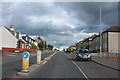
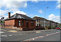
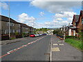
2
Lime Road, New Cumnock
Junction with Hamilton Drive.
Image: © JThomas
Taken: 22 May 2021
0.04 miles
3
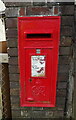
George VI postbox on Afton Bridgend, New Cumnock
Postbox No. KA18 8.
Image: © JThomas
Taken: 22 May 2021
0.09 miles
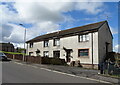
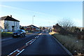
4
Houses on Afton Bridgend (A76), New Cumnock
Image: © JThomas
Taken: 22 May 2021
0.09 miles
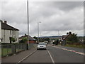
8
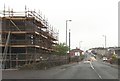
Afton Bridgend from The Spar stores
A76 looking east
Image: © John Firth
Taken: 19 May 2013
0.10 miles
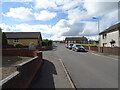
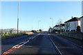
9
Afton Bridgend (A76), New Cumnock
Looking west.
Image: © JThomas
Taken: 22 May 2021
0.11 miles