IMAGES TAKEN NEAR TO
Ashmark Avenue, CUMNOCK, KA18 4ES
Introduction
This page details the photographs taken nearby to Ashmark Avenue, KA18 4ES by members of the Geograph project.
The Geograph project started in 2005 with the aim of publishing, organising and preserving representative images for every square kilometre of Great Britain, Ireland and the Isle of Man.

There are currently over 7.5m images from over14,400 individuals and you can help contribute to the project by visiting https://www.geograph.org.uk
Image Map
Images are licensed for reuse under creativecommons.org/licenses/by-sa/2.0
Notes
- Clicking on the map will re-center to the selected point.
- The higher the marker number, the further away the image location is from the centre of the postcode.
Image Listing (21 Images Found)
Images are licensed for reuse under creativecommons.org/licenses/by-sa/2.0
Image
Details
Distance
1
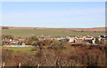
New Cumnock
Viewed from the Cemetery.
Image: © Billy McCrorie
Taken: 18 Nov 2019
0.15 miles
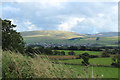
3
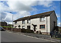
Houses in New Cumnock
Housing in the village of New Cumnock.
Image: © Peter Mackenzie
Taken: 2 May 2019
0.15 miles
7
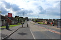
Afton Bridgend
Looking along the A76, where it is called Afton Bridgend, on the edge of New Cumnock.
Image: © Mary and Angus Hogg
Taken: 20 Sep 2013
0.20 miles
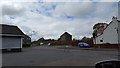
8
Lime Road, New Cumnock
Junction with Hamilton Drive.
Image: © JThomas
Taken: 22 May 2021
0.20 miles
9
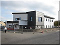
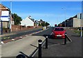
Valley Medical Practice
This new Doctors Surgery replaces the existing Surgery which is located behind the new building.
Image: © Graeme Yuill
Taken: 30 Sep 2013
0.20 miles
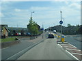
10
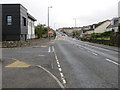
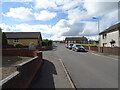
Afton Bridgend (A76) at Valley Medical Practice, New Cumnock
Looking eastward.
Image: © Peter Wood
Taken: 10 Sep 2017
0.21 miles