IMAGES TAKEN NEAR TO
Cameron Crescent, CUMNOCK, KA18 3TA
Introduction
This page details the photographs taken nearby to Cameron Crescent, KA18 3TA by members of the Geograph project.
The Geograph project started in 2005 with the aim of publishing, organising and preserving representative images for every square kilometre of Great Britain, Ireland and the Isle of Man.

There are currently over 7.5m images from over14,400 individuals and you can help contribute to the project by visiting https://www.geograph.org.uk
Image Map
Images are licensed for reuse under creativecommons.org/licenses/by-sa/2.0
Notes
- Clicking on the map will re-center to the selected point.
- The higher the marker number, the further away the image location is from the centre of the postcode.
Image Listing (7 Images Found)
Images are licensed for reuse under creativecommons.org/licenses/by-sa/2.0
Image
Details
Distance
2
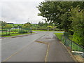
Netherthird - Craigens Road joining Glaisnock Road (B7083)
Looking south-westward.
Image: © Peter Wood
Taken: 12 Sep 2016
0.16 miles
3
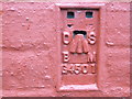
Ordnance Survey Flush Bracket G4501
This can be found on the wall of a house - private dwelling - in Craigens Road, Netherthird.
For more detail see : http://www.bench-marks.org.uk/bm17118
Image: © Peter Wood
Taken: 12 Sep 2016
0.16 miles
5
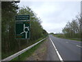
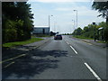
A76 approaching Skerrington Roundabout
Towards Dumfries.
Image: © JThomas
Taken: 21 May 2021
0.20 miles
6
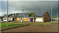
Netherthird Community Centre
A modern building on the southern outskirts of Cumnock.
Image: © Mary and Angus Hogg
Taken: 24 Feb 2024
0.21 miles
7
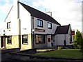
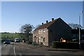
The Thistle Inn
Front of the Thistle Inn, Cumnock.
Image: © Colin Kinnear
Taken: 1 Nov 2008
0.21 miles