IMAGES TAKEN NEAR TO
Muirkirk, CUMNOCK, KA18 3RX
Introduction
This page details the photographs taken nearby to KA18 3RX by members of the Geograph project.
The Geograph project started in 2005 with the aim of publishing, organising and preserving representative images for every square kilometre of Great Britain, Ireland and the Isle of Man.

There are currently over 7.5m images from over14,400 individuals and you can help contribute to the project by visiting https://www.geograph.org.uk
Image Map (Loading...)


Getting Data...Please wait
Leaflet Map data © OpenStreetMap
Images are licensed for reuse under creativecommons.org/licenses/by-sa/2.0
Notes
- Clicking on the map will re-center to the selected point.
- The higher the marker number, the further away the image location is from the centre of the postcode.
Image Listing (44 Images Found)
Images are licensed for reuse under creativecommons.org/licenses/by-sa/2.0
Image
Details
Distance
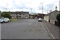
3
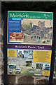
Muirkirk
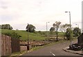
A view over Crossflat Bridge & River Ayr
Image: © Leslie Barrie
Taken: 29 Aug 2010
0.08 miles
4
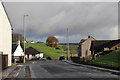
Bungalow opposite Kerlstone House on A70
Image: © John Firth
Taken: 16 Apr 2015
0.08 miles
6
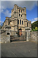
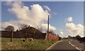
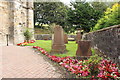
Muirkirk Parish Church
This Church of Scotland building was erected in 1812 and renovated in 1883. The churchyard contains some interesting old gravestones.
Image: © Walter Baxter
Taken: 22 Sep 2008
0.10 miles
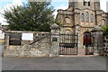
10
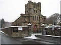
Muirkirk Parish Kirk
Many ancient graves are contained in the kirkyard.
Image: © James Denham
Taken: 5 Feb 2009
0.11 miles