IMAGES TAKEN NEAR TO
Main Street, CUMNOCK, KA18 3RA
Introduction
This page details the photographs taken nearby to Main Street, KA18 3RA by members of the Geograph project.
The Geograph project started in 2005 with the aim of publishing, organising and preserving representative images for every square kilometre of Great Britain, Ireland and the Isle of Man.

There are currently over 7.5m images from over14,400 individuals and you can help contribute to the project by visiting https://www.geograph.org.uk
Image Map
Images are licensed for reuse under creativecommons.org/licenses/by-sa/2.0
Notes
- Clicking on the map will re-center to the selected point.
- The higher the marker number, the further away the image location is from the centre of the postcode.
Image Listing (32 Images Found)
Images are licensed for reuse under creativecommons.org/licenses/by-sa/2.0
Image
Details
Distance
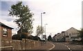
2
Main Street, Muirkirk
The lights at the foot of Glasgow Road.
Image: © Richard Webb
Taken: 7 Jun 2015
0.02 miles
3
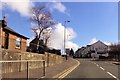
Smallburn Road from Furnace Road junction
Image: © John Firth
Taken: 16 Apr 2015
0.02 miles
5
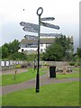
Direction Sign in Muirkirk Heritage Park
The sign gives directions (no distances) to local points of interest in the Muirkirk area.
Image: © G Laird
Taken: 22 Aug 2017
0.02 miles
7
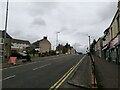
A70 passing through Muirkirk
The picture looks along Muirkirk Main Street which is also the A70. Temporary road signs warn that the road further east is currently closed: https://www.southlanarkshire.gov.uk/view/news/article/1046/Plan_ahead_for_A70_roadworks_closure Fortunately my journey went west.
Image: © Alec MacKinnon
Taken: 19 Aug 2021
0.03 miles
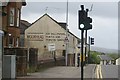
8
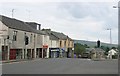
Muirkirk
Junction at the centre of this once busy industrial town, now a village up on the moors of Eastern Ayrshire. The ironworks are long gone, as are the coal mines, they dig big holes where villages once stood now.
Muirkirk was the first town to have piped gas.
Image: © Richard Webb
Taken: 16 Aug 2005
0.03 miles
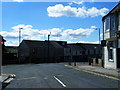
9
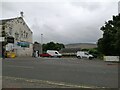
Main Street car park, Muirkirk
The car park sits at the west end of the row of businesses on Main Street. Cairn Table is on the horizon behind.
Image: © Alec MacKinnon
Taken: 19 Aug 2021
0.03 miles
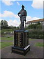
10
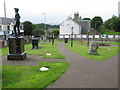
Muirkirk Heritage Park (Miners' Memorial Garden)
Situated in the centre of Muirkirk, the park was opened by Professor Stuart Murray on 18th September 2003 and commemorates Muirkirk's mining past, in particular 79 miners who lost their lives. The last pit to close in the Muirkirk area was Kames in 1968. The park is stopping point 9 on the River Ayr Way.
Image: © G Laird
Taken: 22 Aug 2017
0.03 miles