IMAGES TAKEN NEAR TO
Muirkirk, CUMNOCK, KA18 3NQ
Introduction
This page details the photographs taken nearby to KA18 3NQ by members of the Geograph project.
The Geograph project started in 2005 with the aim of publishing, organising and preserving representative images for every square kilometre of Great Britain, Ireland and the Isle of Man.

There are currently over 7.5m images from over14,400 individuals and you can help contribute to the project by visiting https://www.geograph.org.uk
Image Map
Images are licensed for reuse under creativecommons.org/licenses/by-sa/2.0
Notes
- Clicking on the map will re-center to the selected point.
- The higher the marker number, the further away the image location is from the centre of the postcode.
Image Listing (3 Images Found)
Images are licensed for reuse under creativecommons.org/licenses/by-sa/2.0
Image
Details
Distance
3
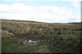
Watershed
The sloping land following the line of the B743 to its junction with the A70 to Muirkirk, is part of a ridge separating the drainage to the R.Ayr from that to the Greenock Water. The ruin of West Dalfram can just be seen to the middle right of the photograph. The wet heavy nature of the ground here can also be seen.
Image: © Bob Forrest
Taken: 26 Feb 2007
0.24 miles