IMAGES TAKEN NEAR TO
Cronberry, CUMNOCK, KA18 3NA
Introduction
This page details the photographs taken nearby to KA18 3NA by members of the Geograph project.
The Geograph project started in 2005 with the aim of publishing, organising and preserving representative images for every square kilometre of Great Britain, Ireland and the Isle of Man.

There are currently over 7.5m images from over14,400 individuals and you can help contribute to the project by visiting https://www.geograph.org.uk
Image Map
Images are licensed for reuse under creativecommons.org/licenses/by-sa/2.0
Notes
- Clicking on the map will re-center to the selected point.
- The higher the marker number, the further away the image location is from the centre of the postcode.
Image Listing (9 Images Found)
Images are licensed for reuse under creativecommons.org/licenses/by-sa/2.0
Image
Details
Distance
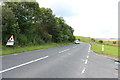
1
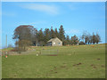
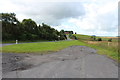
Field, Boghead
Looking towards moorland beyond Boghead Lane.
Image: © Richard Webb
Taken: 5 May 2016
0.07 miles
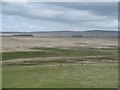
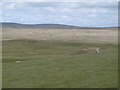
5
Opencast, Boghead
There are extensive opencast pits to the east of the A70.
Image: © Richard Webb
Taken: 5 May 2016
0.11 miles
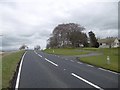
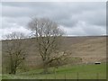
6
Pasture, Boghead
Ewe and lamb on dry sloping ground.
Image: © Richard Webb
Taken: 5 May 2016
0.12 miles
7
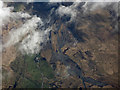
Opencast coal mines at Boghead from the air
South of the A70 road, between Cumnock and Muirkirk.
Image: © Thomas Nugent
Taken: 20 Mar 2017
0.14 miles
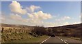
8
Road to Lugar near Boghead
From a lay-by.
Image: © Billy McCrorie
Taken: 7 Aug 2014
0.22 miles