IMAGES TAKEN NEAR TO
Logan, CUMNOCK, KA18 3HX
Introduction
This page details the photographs taken nearby to KA18 3HX by members of the Geograph project.
The Geograph project started in 2005 with the aim of publishing, organising and preserving representative images for every square kilometre of Great Britain, Ireland and the Isle of Man.

There are currently over 7.5m images from over14,400 individuals and you can help contribute to the project by visiting https://www.geograph.org.uk
Image Map
Images are licensed for reuse under creativecommons.org/licenses/by-sa/2.0
Notes
- Clicking on the map will re-center to the selected point.
- The higher the marker number, the further away the image location is from the centre of the postcode.
Image Listing (9 Images Found)
Images are licensed for reuse under creativecommons.org/licenses/by-sa/2.0
Image
Details
Distance
1
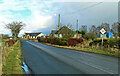
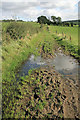
Towards Stonepark
Viewed on Loganhill Road, which connects Logan village with Netherthird, on the edge of Cumnock.
Image: © Mary and Angus Hogg
Taken: 24 Feb 2024
0.01 miles
3
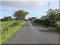
Loganhill Road at Stonepark
Looking north-eastward.
Image: © Peter Wood
Taken: 11 Sep 2016
0.03 miles
4
A farm track near Stonepark
Provides access from Loganhill Road to the martyr's grave Image] in a field behind the trees.
Image: © Walter Baxter
Taken: 22 Sep 2008
0.08 miles
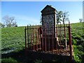
7
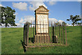
A martyr's grave
A memorial, west-northwest of Meikle Auchengibbert Farm, to the Covenanter John McGeachan. The inscription reads:-
HERE LIES
JOHN McGEACHAN
WHO FOR HIS CONSTANT
ADHERENCE TO THE WORD OF
GOD
PROSECUTING THE ENDS OF
NATIONAL VALUE AND
COVENANT AND APPEARING FOR
THE RESCUE OF THE
REV DAVID HOUSTON
ONE OF THE PERSECUTED
MINISTERS OF THE GOSPEL
WAS SHOT AT BELLOW PATH BY
A PARTY OF BLOODY DRAGOONS
XXVIITH JULY MDCLXXXXIII
On the other side is inscribed:-
THIS
Stone was Erected by the
Proceeds of a Sermon
Preached by the
Rev Mr JAMES CURRIE
Of Catrine 28th August 1836
An inscription on a small stone to the side of the monument reads:-
THE PERSECUTED MINISTER
OF THE GOSPEL
WAS SHOT AT BELLO
PATH BY A PARTY OF THE
BLOODY DRAGOONS
JULY 28 1688
ERECTED ANNO 1728
Image: © Walter Baxter
Taken: 22 Sep 2008
0.18 miles
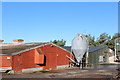
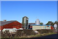
8

Poultry Unit
Located to the east of Thomarston farm on slightly higher land and beside the minor road from Craigens (NS58180). It is close to the junction of this road with the minor road from the Glenmuir Water area (NS6120).
Image: © Bob Forrest
Taken: 20 Mar 2007
0.20 miles