IMAGES TAKEN NEAR TO
William Murdoch Walk, KA18 3ER
Introduction
This page details the photographs taken nearby to William Murdoch Walk, KA18 3ER by members of the Geograph project.
The Geograph project started in 2005 with the aim of publishing, organising and preserving representative images for every square kilometre of Great Britain, Ireland and the Isle of Man.

There are currently over 7.5m images from over14,400 individuals and you can help contribute to the project by visiting https://www.geograph.org.uk
Image Map
Images are licensed for reuse under creativecommons.org/licenses/by-sa/2.0
Notes
- Clicking on the map will re-center to the selected point.
- The higher the marker number, the further away the image location is from the centre of the postcode.
Image Listing (23 Images Found)
Images are licensed for reuse under creativecommons.org/licenses/by-sa/2.0
Image
Details
Distance
2
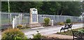
Lugar War memorial
Lugar War memorial.
Image: © Colin Kinnear
Taken: 10 Jul 2020
0.06 miles
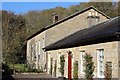
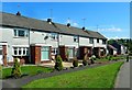
4
Refurbished Buildings in Lugar
This property in Lugar has been tastefully refurbished for housing after a long period of disuse.
Image: © Mary and Angus Hogg
Taken: 31 May 2014
0.09 miles
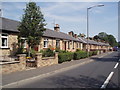
5

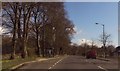
Housing along A70 approaching Peesweep Brae
Image: © John Firth
Taken: 16 Apr 2015
0.11 miles
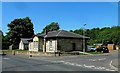
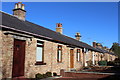
7
Park Terrace, Lugar
A row of cottages beside the A70.
Image: © Richard Webb
Taken: 5 May 2016
0.13 miles
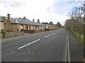
9
Roadside Housing at Lugar
These houses lie along the A70 in Lugar village.
Image: © Mary and Angus Hogg
Taken: 31 May 2014
0.16 miles
10
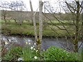
Lugar Water
Beside the A70 at Park Terrace.
Image: © Richard Webb
Taken: 5 May 2016
0.17 miles