IMAGES TAKEN NEAR TO
Kilbrennan Avenue, CUMNOCK, KA18 3BH
Introduction
This page details the photographs taken nearby to Kilbrennan Avenue, KA18 3BH by members of the Geograph project.
The Geograph project started in 2005 with the aim of publishing, organising and preserving representative images for every square kilometre of Great Britain, Ireland and the Isle of Man.

There are currently over 7.5m images from over14,400 individuals and you can help contribute to the project by visiting https://www.geograph.org.uk
Image Map
Images are licensed for reuse under creativecommons.org/licenses/by-sa/2.0
Notes
- Clicking on the map will re-center to the selected point.
- The higher the marker number, the further away the image location is from the centre of the postcode.
Image Listing (2 Images Found)
Images are licensed for reuse under creativecommons.org/licenses/by-sa/2.0
Image
Details
Distance
1

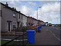
Craigens Council Housing Scheme
Southernmost part of the Craigens council housing area. At present it is in a rural setting, virtually surrounded by improved grassland grazed by cattle and sheep. More recent private housing along the A76(T) can be seen on the middle right of the photograph, while new factories on the industrial estate at Netherthird are also making demands on the farm land at the edge of Cumnock burgh.
Image: © Bob Forrest
Taken: 20 Mar 2007
0.02 miles