IMAGES TAKEN NEAR TO
Ochiltree, CUMNOCK, KA18 2RQ
Introduction
This page details the photographs taken nearby to KA18 2RQ by members of the Geograph project.
The Geograph project started in 2005 with the aim of publishing, organising and preserving representative images for every square kilometre of Great Britain, Ireland and the Isle of Man.

There are currently over 7.5m images from over14,400 individuals and you can help contribute to the project by visiting https://www.geograph.org.uk
Image Map
Images are licensed for reuse under creativecommons.org/licenses/by-sa/2.0
Notes
- Clicking on the map will re-center to the selected point.
- The higher the marker number, the further away the image location is from the centre of the postcode.
Image Listing (5 Images Found)
Images are licensed for reuse under creativecommons.org/licenses/by-sa/2.0
Image
Details
Distance

3
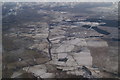
East Ayrshire from the air
Looking east along the B7046 Skares Road from a Ryanair plane which is just about above Sinclairston, having just taken off from Prestwick Airport. Cumnock is just visible in the top left corner. Close inspection of the larger sized image reveals many quarries and gravel pits.
Image: © Thomas Nugent
Taken: 1 Mar 2010
0.11 miles