IMAGES TAKEN NEAR TO
Skares, CUMNOCK, KA18 2RF
Introduction
This page details the photographs taken nearby to KA18 2RF by members of the Geograph project.
The Geograph project started in 2005 with the aim of publishing, organising and preserving representative images for every square kilometre of Great Britain, Ireland and the Isle of Man.

There are currently over 7.5m images from over14,400 individuals and you can help contribute to the project by visiting https://www.geograph.org.uk
Image Map
Images are licensed for reuse under creativecommons.org/licenses/by-sa/2.0
Notes
- Clicking on the map will re-center to the selected point.
- The higher the marker number, the further away the image location is from the centre of the postcode.
Image Listing (16 Images Found)
Images are licensed for reuse under creativecommons.org/licenses/by-sa/2.0
Image
Details
Distance
4
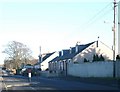
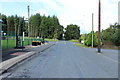
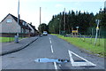
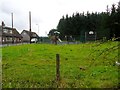
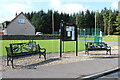
Skares village
Skares is at the centre of a former Ayrshire coal mining area. The former Whitehill Colliery was just a mile to the north. Skares Row was a set of three miners' rows just outside Cumnock. When the mines closed the houses were emptied from 1949 onwards and later demolished. A new open-cast coal mine operates nearby.
Image: © Gordon Brown
Taken: 5 Feb 2007
0.05 miles