IMAGES TAKEN NEAR TO
Ochiltree, CUMNOCK, KA18 2QQ
Introduction
This page details the photographs taken nearby to KA18 2QQ by members of the Geograph project.
The Geograph project started in 2005 with the aim of publishing, organising and preserving representative images for every square kilometre of Great Britain, Ireland and the Isle of Man.

There are currently over 7.5m images from over14,400 individuals and you can help contribute to the project by visiting https://www.geograph.org.uk
Image Map
Images are licensed for reuse under creativecommons.org/licenses/by-sa/2.0
Notes
- Clicking on the map will re-center to the selected point.
- The higher the marker number, the further away the image location is from the centre of the postcode.
Image Listing (5 Images Found)
Images are licensed for reuse under creativecommons.org/licenses/by-sa/2.0
Image
Details
Distance
1
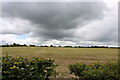
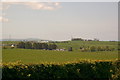
Near Gargowan
A mid-March view of lowland central Ayrshire near Gargowan Farm.
Image: © Mary and Angus Hogg
Taken: 10 Mar 2016
0.12 miles
2
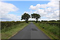
Arran View
The snow-topped island of Arran is framed between these two beech trees near Gargowan.
Image: © Mary and Angus Hogg
Taken: 10 Mar 2016
0.13 miles
3
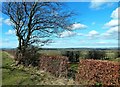
Near Gargowan Farm, Ayrshire
This photo was taken with my back to the entrance to Gargowan Farm, between Ochiltree and Stair. The white building near the horizon is a garden centre called Nurseries Direct, and beyond that can be seen the Heads of Ayr.
Image: © L J Cunningham
Taken: 10 May 2005
0.14 miles