IMAGES TAKEN NEAR TO
Well Road, CUMNOCK, KA18 2JZ
Introduction
This page details the photographs taken nearby to Well Road, KA18 2JZ by members of the Geograph project.
The Geograph project started in 2005 with the aim of publishing, organising and preserving representative images for every square kilometre of Great Britain, Ireland and the Isle of Man.

There are currently over 7.5m images from over14,400 individuals and you can help contribute to the project by visiting https://www.geograph.org.uk
Image Map
Images are licensed for reuse under creativecommons.org/licenses/by-sa/2.0
Notes
- Clicking on the map will re-center to the selected point.
- The higher the marker number, the further away the image location is from the centre of the postcode.
Image Listing (43 Images Found)
Images are licensed for reuse under creativecommons.org/licenses/by-sa/2.0
Image
Details
Distance
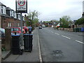
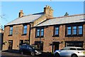
1
Church Street, Auchinleck
Local authority housing area in Auchinleck.
Image: © Mary and Angus Hogg
Taken: 17 Jan 2019
0.13 miles
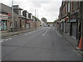
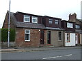
2
The Railway Hotel & Restaurant, Auchinleck
On Main Street (B7083).
Image: © JThomas
Taken: 21 May 2021
0.13 miles
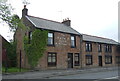
3
The Railway Hotel & Restaurant, Main Street, Auchinleck
Image: © Leslie Barrie
Taken: 10 Nov 2013
0.13 miles
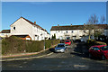
5
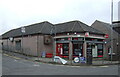
Post Office and shop on Main Street (B7083), Auchinleck
Image: © JThomas
Taken: 21 May 2021
0.14 miles
6
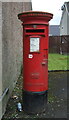
Elizabethan postbox on Main Street, Auchinleck
Postbox No. KA18 31.
See Image] for context.
Image: © JThomas
Taken: 21 May 2021
0.14 miles
7
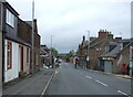
Main Street, Auchinleck
Showing position of Postbox No. KA18 31.
See Image] for postbox.
Image: © JThomas
Taken: 21 May 2021
0.15 miles