IMAGES TAKEN NEAR TO
Glenshamrock Drive, CUMNOCK, KA18 2EH
Introduction
This page details the photographs taken nearby to Glenshamrock Drive, KA18 2EH by members of the Geograph project.
The Geograph project started in 2005 with the aim of publishing, organising and preserving representative images for every square kilometre of Great Britain, Ireland and the Isle of Man.

There are currently over 7.5m images from over14,400 individuals and you can help contribute to the project by visiting https://www.geograph.org.uk
Image Map (Loading...)


Getting Data...Please wait
Leaflet Map data © OpenStreetMap
Images are licensed for reuse under creativecommons.org/licenses/by-sa/2.0
Notes
- Clicking on the map will re-center to the selected point.
- The higher the marker number, the further away the image location is from the centre of the postcode.
Image Listing (3 Images Found)
Images are licensed for reuse under creativecommons.org/licenses/by-sa/2.0
Image
Details
Distance
1
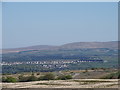
Auchinleck, and Blacksidend
A view of Auchinleck
from near Knockdunder, Skares.
Image: © Rab McMurdo
Taken: 6 May 2020
0.05 miles
2
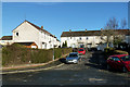
Church Street, Auchinleck
Local authority housing area in Auchinleck.
Image: © Mary and Angus Hogg
Taken: 17 Jan 2019
0.13 miles
3
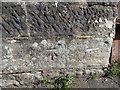
Bench mark
Bench mark on old railway bridge on Coal Road,
Auchinleck.
Image: © Rab McMurdo
Taken: 28 May 2020
0.24 miles